Canvas Print > Arts > Artists > J > Japanese School Japanese School
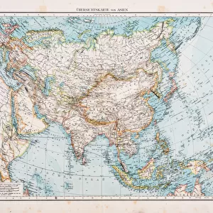
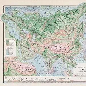
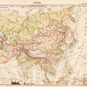
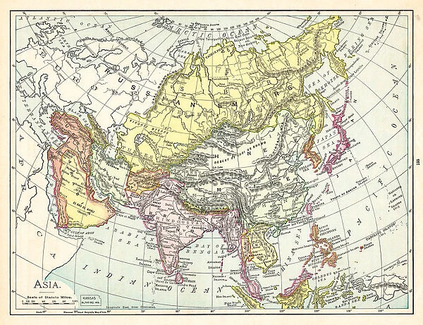
Canvas Print : Map of Asia 1895


![]()
Canvas Prints from Fine Art Storehouse
Map of Asia 1895
The Rand-McNally Grammar School Geography 1895 - Chicago & New York
Unleash your creativity and transform your space into a visual masterpiece!
THEPALMER
Media ID 14824639
© This content is subject to copyright
China East Asia India Indochina Japan Vietnam
20"x16" (51x41cm) Canvas Print
Step back in time with our exquisite Canvas Print of the Map of Asia 1895 by THEPALMER from our Media Storehouse Fine Art Collection. This vintage map, originally published by Rand-McNally for grammar school geography in 1895, adds an intriguing touch of history to any room. The intricate details of the map are beautifully rendered on high-quality canvas, creating a stunning work of art that tells a story of a bygone era. Perfect for history enthusiasts, educators, or anyone who appreciates the beauty of vintage maps, this Canvas Print is sure to make a statement in your home or office.
Delivered stretched and ready to hang our premium quality canvas prints are made from a polyester/cotton blend canvas and stretched over a 1.25" (32mm) kiln dried knot free wood stretcher bar. Packaged in a plastic bag and secured to a cardboard insert for safe transit.
Canvas Prints add colour, depth and texture to any space. Professionally Stretched Canvas over a hidden Wooden Box Frame and Ready to Hang
Estimated Product Size is 50.8cm x 40.6cm (20" x 16")
These are individually made so all sizes are approximate
Artwork printed orientated as per the preview above, with landscape (horizontal) orientation to match the source image.
FEATURES IN THESE COLLECTIONS
> Arts
> Artists
> J
> Japanese School Japanese School
> Asia
> India
> Related Images
> Asia
> Japan
> Related Images
> Asia
> Related Images
> Asia
> Vietnam
> Related Images
> Fine Art Storehouse
> Map
> Historical Maps
EDITORS COMMENTS
In this print titled "Map of Asia 1895" we are transported back in time to the late 19th century, where cartography was a true art form. The map, originally featured in "The Rand-McNally Grammar School Geography 1895" publication from Chicago and New York, offers us a glimpse into the intricate details of Asia's vast landscape. As our eyes wander across the image, we are immediately drawn to the richly illustrated regions that make up this diverse continent. From China's majestic Great Wall winding its way through mountains and valleys to India's vibrant tapestry of cultures and traditions, every corner tells a unique story waiting to be explored. The map also highlights Indochina's lush forests and rivers flowing gracefully through Vietnam's picturesque landscapes. Further eastward lies Japan, with its archipelago meticulously depicted along with its iconic Mount Fuji standing tall amidst serene surroundings. "The Map of Asia 1895" is not just an artistic representation; it serves as a historical document that captures the geopolitical boundaries during that era. It invites us to reflect on how much has changed over time while appreciating the enduring beauty of these ancient lands. With THEPALMER’s expert touch in preserving this piece of history through fine art printing techniques, this print becomes more than just an aesthetic addition to any space—it becomes a window into another world for those who gaze upon it.
MADE IN THE USA
Safe Shipping with 30 Day Money Back Guarantee
FREE PERSONALISATION*
We are proud to offer a range of customisation features including Personalised Captions, Color Filters and Picture Zoom Tools
SECURE PAYMENTS
We happily accept a wide range of payment options so you can pay for the things you need in the way that is most convenient for you
* Options may vary by product and licensing agreement. Zoomed Pictures can be adjusted in the Cart.