Canvas Print > Europe > United Kingdom > Maps
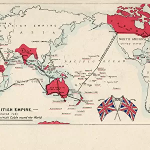
Canvas Print : Map of the British Empire in 1837


![]()
Canvas Prints from Fine Art Storehouse
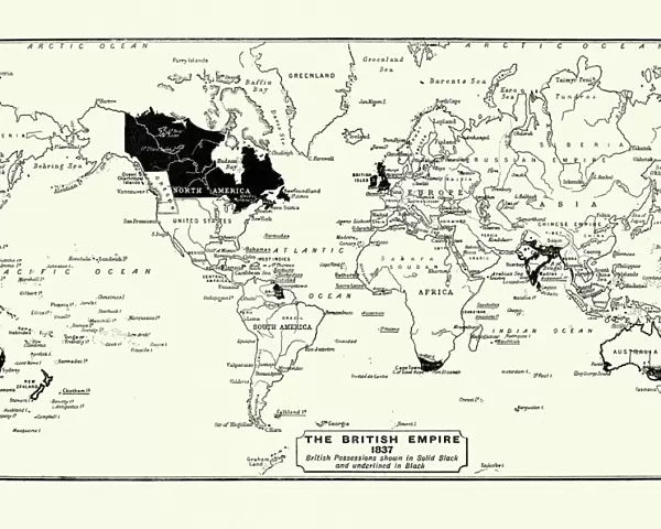
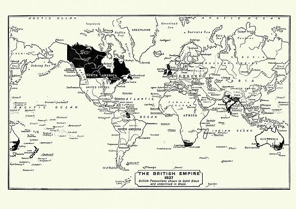
Map of the British Empire in 1837
Map of the British Empire in 1837. At its height, the British Empire was the largest empire in history and, for over a century, was the foremost global power
Unleash your creativity and transform your space into a visual masterpiece!
duncan1890
Media ID 13666689
© duncan1890
1830 1839 78279 95839 British Culture British Empire Empire Ilustration Image Created 1830 1839 Navigational Equipment Retro Revival Styles World Map Image Created 19th Century Retro Styled Victorian Style
20"x16" (51x41cm) Canvas Print
"Step back in time with our exquisite Canvas Print of "Map of the British Empire in 1837" by duncan1890 from Fine Art Storehouse. This captivating piece showcases the expansive reach of the British Empire at its zenith, a testament to its historical significance as the foremost global power for over a century. Bring the rich history of this magnificent era into your home or office with our high-quality Canvas Print, expertly printed on heavy-duty canvas for lasting vibrancy and detail. Each print is carefully crafted to order and arrives ready to hang, making it a perfect addition to any decor."
Delivered stretched and ready to hang our premium quality canvas prints are made from a polyester/cotton blend canvas and stretched over a 1.25" (32mm) kiln dried knot free wood stretcher bar. Packaged in a plastic bag and secured to a cardboard insert for safe transit.
Canvas Prints add colour, depth and texture to any space. Professionally Stretched Canvas over a hidden Wooden Box Frame and Ready to Hang
Estimated Product Size is 50.8cm x 40.6cm (20" x 16")
These are individually made so all sizes are approximate
Artwork printed orientated as per the preview above, with landscape (horizontal) orientation to match the source image.
FEATURES IN THESE COLLECTIONS
> Europe
> United Kingdom
> Maps
> Maps and Charts
> British Empire Maps
> Maps and Charts
> Related Images
> Maps and Charts
> World
> Fine Art Storehouse
> Map
> Historical Maps
EDITORS COMMENTS
This print showcases a remarkable piece of history - the Map of the British Empire in 1837. With its retro revival and 19th-century style, this antique engraved image takes us back to an era when the British Empire reigned supreme. Created between 1830 and 1839, during the height of its power, this illustration represents a pivotal moment in world history. The grandeur of the British Empire is beautifully depicted in this Victorian-style map. Its vast territories spanned across continents, making it the largest empire ever known. For over a century, Britain held unparalleled global influence and was considered the foremost global power. As we gaze upon this meticulously crafted cartography, we are transported to a time when navigational equipment played a crucial role in expanding empires. The attention to detail is awe-inspiring as every corner of this world map reveals intricate borders and territories that once fell under British rule. This image not only captures an important period but also reflects on British culture and its impact on diverse cultures around the globe. It serves as a reminder of our shared past and how historical events shape our present-day world. Duncan1890's artistry has breathed new life into this vintage masterpiece from 1837, allowing us to appreciate both its historical significance and artistic beauty anew.
MADE IN THE USA
Safe Shipping with 30 Day Money Back Guarantee
FREE PERSONALISATION*
We are proud to offer a range of customisation features including Personalised Captions, Color Filters and Picture Zoom Tools
SECURE PAYMENTS
We happily accept a wide range of payment options so you can pay for the things you need in the way that is most convenient for you
* Options may vary by product and licensing agreement. Zoomed Pictures can be adjusted in the Cart.