Canvas Print > Europe > United Kingdom > Maps
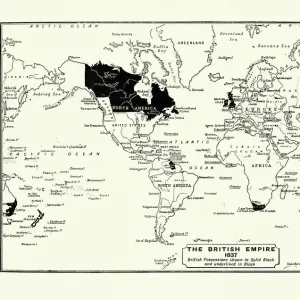
Canvas Print : Map of the British Empire in 1897


![]()
Canvas Prints from Fine Art Storehouse
Map of the British Empire in 1897
Map of the British Empire in 1897. At its height, the British Empire was the largest empire in history and, for over a century, was the foremost global power
Unleash your creativity and transform your space into a visual masterpiece!
duncan1890
Media ID 13666687
© duncan1890
1890 1899 66698 78279 British Culture British Empire Empire Equipment Ilustration Image Created 1890 1899 Navigational Equipment Retro Revival Styles World Map Image Created 19th Century Retro Styled Victorian Style
20"x16" (51x41cm) Canvas Print
"Step back in time and explore the historical expanse of the British Empire with our Canvas Print of "Map of the British Empire in 1897" by duncan1890 from Fine Art Storehouse. This captivating piece showcases the unprecedented reach of the British Empire at the height of its power, making for an intriguing conversation starter in any room. With vivid colors and impressive detail, our Canvas Prints bring historical art to life, adding a touch of sophistication and depth to your home or office decor. Order yours today and embark on a journey through history."
Delivered stretched and ready to hang our premium quality canvas prints are made from a polyester/cotton blend canvas and stretched over a 1.25" (32mm) kiln dried knot free wood stretcher bar. Packaged in a plastic bag and secured to a cardboard insert for safe transit.
Canvas Prints add colour, depth and texture to any space. Professionally Stretched Canvas over a hidden Wooden Box Frame and Ready to Hang
Estimated Product Size is 50.8cm x 40.6cm (20" x 16")
These are individually made so all sizes are approximate
Artwork printed orientated as per the preview above, with landscape (horizontal) orientation to match the source image.
FEATURES IN THESE COLLECTIONS
> Europe
> United Kingdom
> Maps
> Maps and Charts
> British Empire Maps
> Maps and Charts
> Related Images
> Maps and Charts
> World
> Fine Art Storehouse
> Map
> Historical Maps
EDITORS COMMENTS
This print showcases a remarkable piece of history - the Map of the British Empire in 1897. With its retro revival and 19th-century style, this antique engraved image takes us back to an era when the British Empire reigned supreme. At its zenith, it stood as the largest empire ever known, holding unrivaled power for over a century. The illustration beautifully captures the grandeur and extent of this global dominion. Created in the late 19th century, during Queen Victoria's reign, it reflects both Victorian style and cartographic expertise. The intricate details depict territories spanning continents, illustrating Britain's vast influence across diverse cultures. As we gaze upon this nostalgic world map, we are transported to a time when navigational equipment was essential for exploration and conquest. The horizontal layout emphasizes its historical significance while maintaining a retro-styled charm. Duncan1890's creation evokes feelings of curiosity about our past and admiration for British culture. It serves as a reminder of an era long gone but not forgotten—a testament to the enduring legacy left by one nation on countless others. Incorporating this print into any space adds depth and character while paying homage to an extraordinary chapter in human history. Whether displayed in homes or offices, it sparks conversations about imperialism, colonialism, cultural exchange, and ultimately invites us to reflect on how our world has evolved since then.
MADE IN THE USA
Safe Shipping with 30 Day Money Back Guarantee
FREE PERSONALISATION*
We are proud to offer a range of customisation features including Personalised Captions, Color Filters and Picture Zoom Tools
SECURE PAYMENTS
We happily accept a wide range of payment options so you can pay for the things you need in the way that is most convenient for you
* Options may vary by product and licensing agreement. Zoomed Pictures can be adjusted in the Cart.