Canvas Print > Arts > Artists > M > Mexican School Mexican School
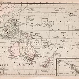
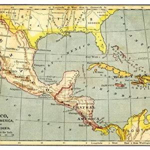
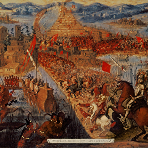
Canvas Print : Map of Mexico and West Indies 1877


![]()
Canvas Prints from Fine Art Storehouse
Map of Mexico and West Indies 1877
Warrens Common School Geography 1877
Unleash your creativity and transform your space into a visual masterpiece!
THEPALMER
Media ID 14824551
© This content is subject to copyright
Caribbean Central America Cuba Dominican Republic Honduras Mexico Nicaragua Panama Puerto Rico West Indies
20"x16" (51x41cm) Canvas Print
Transport yourself back in time with our stunning Canvas Print of the Map of Mexico and the West Indies from 1877, part of the Media Storehouse collection from Fine Art Storehouse. This intricately detailed map, titled "Warrens Common School Geography 1877" by THEPALMER, offers a captivating glimpse into the historical cartography of the Americas. Each canvas print is meticulously crafted with premium materials, ensuring vibrant colors and sharp details that bring this piece to life. Elevate your home or office decor with a unique and educational addition that tells a story of the past. Order now and let history come alive in your space.
Delivered stretched and ready to hang our premium quality canvas prints are made from a polyester/cotton blend canvas and stretched over a 1.25" (32mm) kiln dried knot free wood stretcher bar. Packaged in a plastic bag and secured to a cardboard insert for safe transit.
Canvas Prints add colour, depth and texture to any space. Professionally Stretched Canvas over a hidden Wooden Box Frame and Ready to Hang
Estimated Product Size is 40.6cm x 50.8cm (16" x 20")
These are individually made so all sizes are approximate
Artwork printed orientated as per the preview above, with portrait (vertical) orientation to match the source image.
FEATURES IN THESE COLLECTIONS
> Arts
> Artists
> M
> Mexican School Mexican School
> Maps and Charts
> Related Images
> North America
> Cuba
> Maps
> North America
> Cuba
> Related Images
> North America
> Dominican Republic
> Maps
> North America
> Dominican Republic
> Related Images
> North America
> Honduras
> Maps
> North America
> Honduras
> Related Images
> North America
> Mexico
> Maps
> Fine Art Storehouse
> Map
> Historical Maps
EDITORS COMMENTS
This print titled "Map of Mexico and West Indies 1877" takes us on a visual journey through time, immersing us in the intricate details of geography from over a century ago. A relic from the Warrens Common School Geography collection of 1877, this piece offers a glimpse into the educational tools used during that era. The map itself is an exquisite depiction of Cuba, West Indies, Caribbean, Central America, Dominican Republic, Honduras, Mexico, Nicaragua, Panama and Puerto Rico. Its vibrant colors and meticulous cartography draw our attention to each country's unique shape and topographical features. The artist behind this masterpiece - THEPALMER - has skillfully captured the essence of these regions with precision and artistry. As we gaze upon this historical gem hanging proudly on display at Fine Art Storehouse, we are transported back to a time when exploration was paramount. It serves as a reminder of how far we have come in our understanding of the world around us. This print not only showcases geographical knowledge but also evokes curiosity about past civilizations that once thrived within these lands. Whether you are an avid collector or simply appreciate the beauty found in antique maps like this one by THEPALMER; it is impossible not to be captivated by its allure. So take a moment to immerse yourself in history with this remarkable photographic print – Map of Mexico and West Indies 1877 – an extraordinary testament to human curiosity and discovery.
MADE IN THE USA
Safe Shipping with 30 Day Money Back Guarantee
FREE PERSONALISATION*
We are proud to offer a range of customisation features including Personalised Captions, Color Filters and Picture Zoom Tools
SECURE PAYMENTS
We happily accept a wide range of payment options so you can pay for the things you need in the way that is most convenient for you
* Options may vary by product and licensing agreement. Zoomed Pictures can be adjusted in the Cart.