Canvas Print > Asia > Palestine > Maps
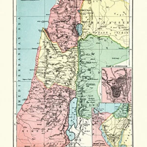
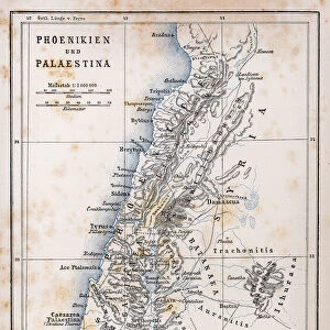
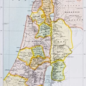
Canvas Print : Map of Palestine 1896


![]()
Canvas Prints from Fine Art Storehouse
Map of Palestine 1896
Andres Allgemeiner Handatlas - Bielefeld und Leipzig 1896
Unleash your creativity and transform your space into a visual masterpiece!
THEPALMER
Media ID 18356853
30"x20" (76x51cm) Canvas Print
Discover the historical depth of the past with our exquisite Canvas Print of the Map of Palestine 1896 by THEPALMER from our Media Storehouse Fine Art Collection. This captivating piece, taken from the Andres Allgemeiner Handatlas published in Bielefeld and Leipzig in 1896, makes an impressive addition to any room. The intricate details of the map are beautifully rendered on the canvas, creating a stunning visual representation of historical geography. Bring a piece of history into your home or office with this unique and thought-provoking artwork.
Delivered stretched and ready to hang our premium quality canvas prints are made from a polyester/cotton blend canvas and stretched over a 1.25" (32mm) kiln dried knot free wood stretcher bar. Packaged in a plastic bag and secured to a cardboard insert for safe transit.
Canvas Prints add colour, depth and texture to any space. Professionally Stretched Canvas over a hidden Wooden Box Frame and Ready to Hang
Estimated Product Size is 50.8cm x 76.2cm (20" x 30")
These are individually made so all sizes are approximate
Artwork printed orientated as per the preview above, with portrait (vertical) orientation to match the source image.
FEATURES IN THESE COLLECTIONS
> Asia
> Palestine
> Related Images
> Maps and Charts
> Related Images
> Fine Art Storehouse
> Map
> Historical Maps
EDITORS COMMENTS
In this print titled "Map of Palestine 1896" we are transported back in time to the late 19th century. The image showcases a meticulously detailed map from Andres Allgemeiner Handatlas, published in Bielefeld und Leipzig in 1896. As we delve into the intricacies of this historical artifact, our eyes are drawn to the rich tapestry of information it holds. The map itself is a testament to cartographic artistry, with its delicate lines and precise labeling capturing the essence of Palestine during that era. It offers a window into a bygone world, where borders were different and territories held distinct identities. Through this visual representation, we gain insights into how people perceived and understood geography over a century ago. Every corner of this vintage map tells stories waiting to be explored - ancient cities dotting the landscape, rivers meandering through lush valleys, and mountains standing tall as silent witnesses to centuries past. It serves as an invaluable resource for historians, geographers, or anyone seeking knowledge about Palestine's geographical layout at that particular moment in history. "The Map of Palestine 1896" print by THEPALMER available at Fine Art Storehouse not only preserves an important piece of cartographic heritage but also invites us on an enchanting journey through time. Whether displayed on walls or cherished within personal collections, it sparks curiosity and fosters appreciation for both artistry and history alike
MADE IN THE USA
Safe Shipping with 30 Day Money Back Guarantee
FREE PERSONALISATION*
We are proud to offer a range of customisation features including Personalised Captions, Color Filters and Picture Zoom Tools
SECURE PAYMENTS
We happily accept a wide range of payment options so you can pay for the things you need in the way that is most convenient for you
* Options may vary by product and licensing agreement. Zoomed Pictures can be adjusted in the Cart.