Canvas Print > Arts > Artists > P > Peruvian School Peruvian School
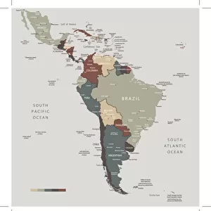
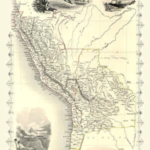
Canvas Print : Map of South America 1877


![]()
Canvas Prints from Fine Art Storehouse
Map of South America 1877
Warrens Common School Geography 1877
Unleash your creativity and transform your space into a visual masterpiece!
THEPALMER
Media ID 14824591
© This content is subject to copyright
Argentine Bolivia Brazil Chile Colombia Ecuador Paraguay Peru South America Venezuela
20"x16" (51x41cm) Canvas Print
Transport yourself back in time with our exquisite Canvas Print of the Map of South America from 1877, created by THEPALMER for Warrens Common School. This Fine Art Storehouse masterpiece captures historical cartography in stunning detail, making it an exceptional addition to any room. The high-quality canvas print brings the intricacies of the map to life, allowing you to explore the geography of South America as it was understood over a century ago. Perfect for history enthusiasts, educators, or anyone seeking a unique and captivating piece of art for their home or office.
Delivered stretched and ready to hang our premium quality canvas prints are made from a polyester/cotton blend canvas and stretched over a 1.25" (32mm) kiln dried knot free wood stretcher bar. Packaged in a plastic bag and secured to a cardboard insert for safe transit.
Canvas Prints add colour, depth and texture to any space. Professionally Stretched Canvas over a hidden Wooden Box Frame and Ready to Hang
Estimated Product Size is 40.6cm x 50.8cm (16" x 20")
These are individually made so all sizes are approximate
Artwork printed orientated as per the preview above, with portrait (vertical) orientation to match the source image.
FEATURES IN THESE COLLECTIONS
> Arts
> Artists
> P
> Peruvian School Peruvian School
> Maps and Charts
> Related Images
> South America
> Argentina
> Maps
> South America
> Argentina
> Related Images
> South America
> Bolivia
> Maps
> South America
> Bolivia
> Related Images
> South America
> Brazil
> Maps
> South America
> Brazil
> Related Images
> South America
> Chile
> Maps
> Fine Art Storehouse
> Map
> Historical Maps
EDITORS COMMENTS
This print titled "Map of South America 1877" takes us back in time to the late 19th century, offering a glimpse into the world as it was over a century ago. The map is sourced from Warrens Common School Geography, an educational resource that played a crucial role in shaping young minds during that era. As we delve into this intricate piece, our eyes are immediately drawn to the rich details and vibrant colors that bring this historical map to life. It showcases countries such as Chile, Peru, Argentina, Bolivia, Brazil, Colombia, Ecuador, Paraguay, Venezuela and more; each delineated with precision and care. The artist behind this remarkable work is THEPALMER. Through their skilled craftsmanship and attention to detail, they have successfully captured the essence of South America's geography in 1877. This print serves not only as a decorative piece but also as an educational tool for those interested in exploring the continent's past. Whether you're an avid history enthusiast or simply appreciate fine art prints like this one from Fine Art Storehouse collection - there is no denying the allure of "Map of South America 1877". Let it transport you back in time and ignite your curiosity about how these lands have evolved since then.
MADE IN THE USA
Safe Shipping with 30 Day Money Back Guarantee
FREE PERSONALISATION*
We are proud to offer a range of customisation features including Personalised Captions, Color Filters and Picture Zoom Tools
SECURE PAYMENTS
We happily accept a wide range of payment options so you can pay for the things you need in the way that is most convenient for you
* Options may vary by product and licensing agreement. Zoomed Pictures can be adjusted in the Cart.