Canvas Print > Europe > Bosnia and Herzegovina > Maps
Canvas Print : Old map of Serbia and Bosnia, steel engraving, published 1857


![]()
Canvas Prints from Fine Art Storehouse
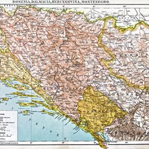
Old map of Serbia and Bosnia, steel engraving, published 1857
Old map of Serbia and Bosnia. Steel engraving with hand coloured borderlines, published in 1857
Unleash your creativity and transform your space into a visual masterpiece!
ZU_09
Media ID 35842846
20"x16" (51x41cm) Canvas Print
Step back in time with our exquisite Canvas Print of an Old Map of Serbia and Bosnia. This stunning piece, published in 1857 by ZU_09, is a beautiful steel engraving adorned with intricately hand-colored borderlines. Each detail of this vintage map is meticulously rendered, transporting you back to an era of exploration and discovery. Hang this captivating work of art in your home or office to add a touch of history and character to your space. The high-quality canvas print is sure to be a conversation starter and a cherished addition to your collection.
Delivered stretched and ready to hang our premium quality canvas prints are made from a polyester/cotton blend canvas and stretched over a 1.25" (32mm) kiln dried knot free wood stretcher bar. Packaged in a plastic bag and secured to a cardboard insert for safe transit.
Canvas Prints add colour, depth and texture to any space. Professionally Stretched Canvas over a hidden Wooden Box Frame and Ready to Hang
Estimated Product Size is 50.8cm x 40.6cm (20" x 16")
These are individually made so all sizes are approximate
Artwork printed orientated as per the preview above, with landscape (horizontal) orientation to match the source image.
FEATURES IN THESE COLLECTIONS
> Europe
> Bosnia and Herzegovina
> Maps
> Europe
> Serbia
> Related Images
> Maps and Charts
> Bosnia and Herzegovina
> Fine Art Storehouse
> Map
> Historical Maps
EDITORS COMMENTS
This exquisite steel engraving, titled 'Old Map of Serbia and Bosnia,' dates back to 1857. The intricate details of this antique map are a testament to the cartographic skills of the time. The map covers the regions of Serbia and Bosnia, two historically rich and culturally diverse areas in Southeastern Europe. The borders of various principalities and territories are delineated with hand-coloured lines, adding an artistic touch to the otherwise monochrome engraving. The map offers a glimpse into the political landscape of the 19th century, with the Austrian Empire, the Ottoman Empire, and various smaller principalities and states marked out in their respective territories. The Danube River, Sava River, and Drina River are depicted with remarkable accuracy, providing a sense of the geographical features of the region. The Old Map of Serbia and Bosnia is not only a historical document, but also a work of art. The intricate engraving technique, combined with the vibrant hand-coloured borders, creates a visual feast for the eyes. The map serves as a reminder of the rich history and complex political landscape of the Balkans during the 19th century. It is a must-have for collectors of historical maps, cartography enthusiasts, and anyone with an interest in European history and culture.
MADE IN THE USA
Safe Shipping with 30 Day Money Back Guarantee
FREE PERSONALISATION*
We are proud to offer a range of customisation features including Personalised Captions, Color Filters and Picture Zoom Tools
SECURE PAYMENTS
We happily accept a wide range of payment options so you can pay for the things you need in the way that is most convenient for you
* Options may vary by product and licensing agreement. Zoomed Pictures can be adjusted in the Cart.