Canvas Print > Arts > Photorealistic artworks > Detailed art pieces > Masterful detailing in art
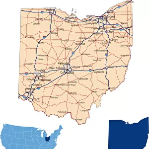
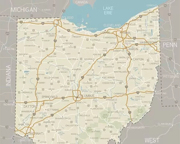
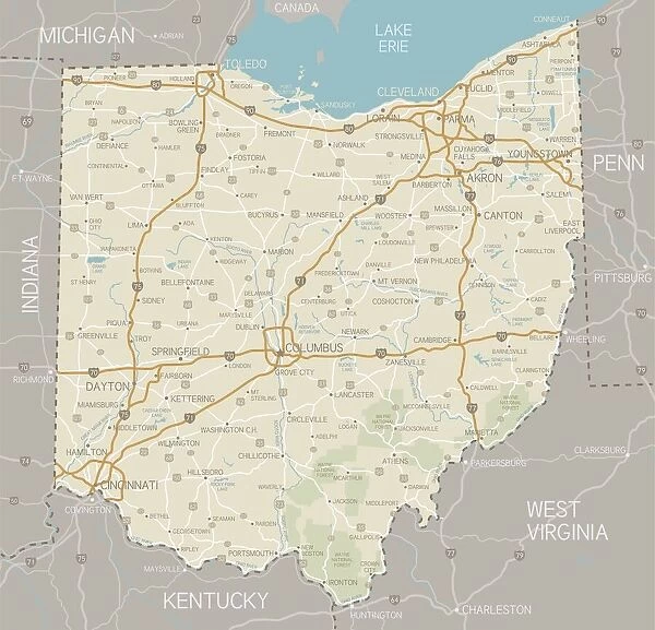
Canvas Print : Ohio Map. A detailed map of Ohio state with cities, roads, major rivers,


![]()
Canvas Prints from Fine Art Storehouse
Ohio Map. A detailed map of Ohio state with cities, roads, major rivers,
A detailed map of Ohio state with cities, roads, major rivers, and lakes plus National Forests. Includes neighboring states and surrounding water
Unleash your creativity and transform your space into a visual masterpiece!
Media ID 15495539
20"x16" (51x41cm) Canvas Print
Discover the beauty of the Buckeye State with our exquisite Ohio Map Canvas Print from Media Storehouse's Fine Art Storehouse. This stunning piece of art showcases a detailed representation of Ohio, including major cities, roads, rivers, and lakes. Delve deeper into the geography of the region as you explore the borders of neighboring states and the vast surrounding water. Each canvas print is meticulously crafted using high-quality materials to ensure vibrant colors and sharp details. Bring a piece of Midwestern charm into your home or office with this beautifully designed Ohio Map Canvas Print.
Delivered stretched and ready to hang our premium quality canvas prints are made from a polyester/cotton blend canvas and stretched over a 1.25" (32mm) kiln dried knot free wood stretcher bar. Packaged in a plastic bag and secured to a cardboard insert for safe transit.
Canvas Prints add colour, depth and texture to any space. Professionally Stretched Canvas over a hidden Wooden Box Frame and Ready to Hang
Estimated Product Size is 50.8cm x 40.6cm (20" x 16")
These are individually made so all sizes are approximate
Artwork printed orientated as per the preview above, with landscape (horizontal) orientation to match the source image.
FEATURES IN THESE COLLECTIONS
> Animals
> Mammals
> Muridae
> Water Mouse
> Arts
> Landscape paintings
> Forest and woodland scenes
> Forest artwork
> Arts
> Landscape paintings
> Waterfall and river artworks
> River artworks
> Arts
> Photorealistic artworks
> Detailed art pieces
> Masterful detailing in art
> Maps and Charts
> Related Images
> Fine Art Storehouse
> Map
> Reference Maps
EDITORS COMMENTS
This print showcases the intricate beauty of Ohio, a state brimming with rich history and natural wonders. The detailed map offers an immersive exploration of the Buckeye State, highlighting its cities, roads, major rivers, lakes, as well as the sprawling National Forests that dot its landscape. From bustling urban centers like Columbus and Cleveland to charming towns nestled amidst picturesque countryside, this map encapsulates the diverse tapestry of Ohio's communities. Each city is marked with precision, inviting viewers to embark on a virtual journey through this vibrant state. The inclusion of neighboring states and surrounding water provides context to Ohio's geographical location within the United States. It serves as a reminder that while Ohio stands proudly on its own merits, it is also part of a larger interconnected region. Beyond serving as a navigational tool or educational resource for geography enthusiasts, this print transcends utility by capturing the essence and allure of Ohio's topography. Its vivid colors breathe life into every contour and landmark depicted on the map. Whether displayed in homes or offices alike, this Fine Art Storehouse print invites viewers to appreciate both the artistry behind cartography and the inherent beauty found within our earthly landscapes. It celebrates not only Ohio but also ignites curiosity about other regions waiting to be explored beyond its borders.
MADE IN THE USA
Safe Shipping with 30 Day Money Back Guarantee
FREE PERSONALISATION*
We are proud to offer a range of customisation features including Personalised Captions, Color Filters and Picture Zoom Tools
SECURE PAYMENTS
We happily accept a wide range of payment options so you can pay for the things you need in the way that is most convenient for you
* Options may vary by product and licensing agreement. Zoomed Pictures can be adjusted in the Cart.