Canvas Print > Arts > Street art graffiti > Digital art > Vector illustrations
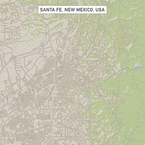
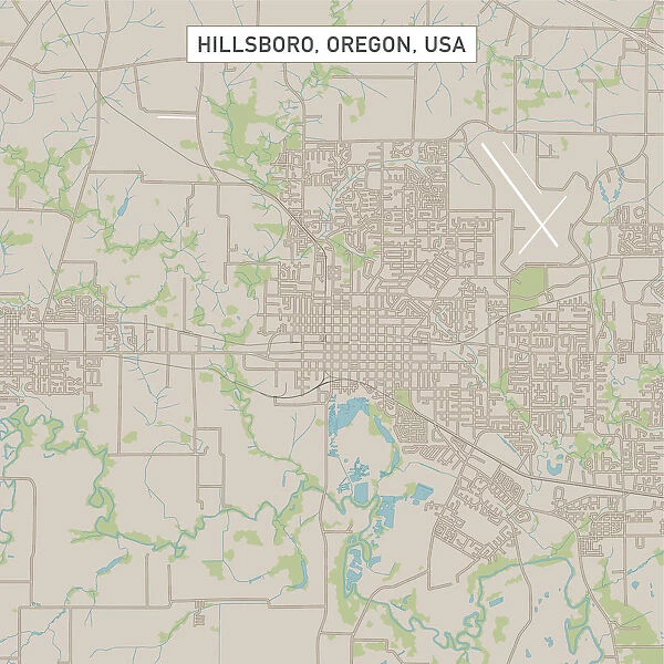
Canvas Print : Hillsboro Oregon US City Street Map


![]()
Canvas Prints from Fine Art Storehouse
Hillsboro Oregon US City Street Map
Vector Illustration of a City Street Map of Hillsboro, Oregon, USA. Scale 1:60, 000.
All source data is in the public domain.
U.S. Geological Survey, US Topo
Used Layers:
USGS The National Map: National Hydrography Dataset (NHD)
USGS The National Map: National Transportation Dataset (NTD)
Unleash your creativity and transform your space into a visual masterpiece!
Frank Ramspott
Media ID 15055011
© Frank Ramspott, all rights reserved
Aerial View City Map Computer Graphic Directly Above Downtown District Gray Oregon Road Map Text Digitally Generated Image Green Color Hillsboro White Color
20"x16" (51x41cm) Canvas Print
Discover the charm of Hillsboro, Oregon with our stunning Canvas Print of a City Street Map by Frank Ramspott from Media Storehouse. This exquisite piece, brought to you by Fine Art Storehouse, is a vector illustration of a City Street Map of Hillsboro, USA, meticulously crafted at a scale of 1:60,000. Boasting all source data in the public domain from the U.S., this unique and captivating canvas print is not just a map, but a work of art that adds character and sophistication to any space. Bring a piece of Hillsboro right into your home and explore its intricacies in vibrant detail.
Delivered stretched and ready to hang our premium quality canvas prints are made from a polyester/cotton blend canvas and stretched over a 1.25" (32mm) kiln dried knot free wood stretcher bar. Packaged in a plastic bag and secured to a cardboard insert for safe transit.
Canvas Prints add colour, depth and texture to any space. Professionally Stretched Canvas over a hidden Wooden Box Frame and Ready to Hang
Estimated Product Size is 40.6cm x 50.8cm (16" x 20")
These are individually made so all sizes are approximate
Artwork printed orientated as per the preview above, with portrait (vertical) orientation to match the source image.
FEATURES IN THESE COLLECTIONS
> Aerial Photography
> Related Images
> Animals
> Insects
> Hemiptera
> Green Scale
> Arts
> Contemporary art
> Digital artwork
> Street art
> Arts
> Landscape paintings
> Waterfall and river artworks
> River artworks
> Arts
> Portraits
> Pop art gallery
> Street art portraits
> Arts
> Street art graffiti
> Digital art
> Digital paintings
> Arts
> Street art graffiti
> Digital art
> Vector illustrations
> Maps and Charts
> Geological Map
> Maps and Charts
> Related Images
> North America
> United States of America
> Lakes
> Related Images
> Fine Art Storehouse
> Map
> Street Maps
> Fine Art Storehouse
> Map
> USA Maps
EDITORS COMMENTS
This print showcases a meticulously detailed city street map of Hillsboro, Oregon, USA. With a scale of 1:60,000, every intricate feature is beautifully illustrated in this vector illustration. The source data used for creating this masterpiece is all from the public domain and includes USGS The National Map: National Hydrography Dataset (NHD) and USGS The National Map: National Transportation Dataset (NTD). The image captures the essence of Hillsboro's downtown district with its bustling streets and vibrant atmosphere. A serene lake and river add to the scenic beauty of this charming city. From major roads to hidden alleys, every corner is depicted on this road map. The artful design combines various colors such as gray, blue, white, and green to create an aesthetically pleasing composition. Digitally generated with precision and attention to detail, this computer graphic offers an aerial view directly above the city. With no people present in the image, it allows viewers to focus solely on exploring the physical geography of Hillsboro through cartography. This unique piece by Frank Ramspott serves as both an informative tool for navigation enthusiasts and a visually striking artwork that can enhance any space or collection.
MADE IN THE USA
Safe Shipping with 30 Day Money Back Guarantee
FREE PERSONALISATION*
We are proud to offer a range of customisation features including Personalised Captions, Color Filters and Picture Zoom Tools
SECURE PAYMENTS
We happily accept a wide range of payment options so you can pay for the things you need in the way that is most convenient for you
* Options may vary by product and licensing agreement. Zoomed Pictures can be adjusted in the Cart.