Canvas Print > Fine Art Storehouse > Map
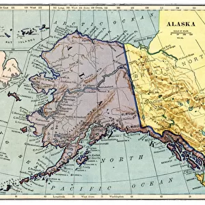
Canvas Print : Alaska map 1893


![]()
Canvas Prints from Fine Art Storehouse
Alaska map 1893
Johnsonas Universal Cyclopedia - Charles Kendall - New York 1893
Unleash your creativity and transform your space into a visual masterpiece!
THEPALMER
Media ID 14756564
© This content is subject to copyright
Alaska Aleutian Islands Bering Sea Polar Sea
30"x20" (76x51cm) Canvas Print
Discover the beauty and history of Alaska with our exquisite Canvas Print of the 1893 Alaska map by THEPALMER from the Media Storehouse Fine Art Storehouse collection. This captivating vintage map, originally published in Johnson's Universal Cyclopedia in New York, showcases intricate cartographic details and captivating illustrations of Alaska during a pivotal time in its exploration. Bring the rich history and natural wonders of Alaska into your home or office with this stunning, museum-quality Canvas Print. Perfect for history enthusiasts, cartography collectors, or anyone who appreciates the beauty of vintage maps. Order yours today and let this unique piece of art tell a story in your space.
Delivered stretched and ready to hang our premium quality canvas prints are made from a polyester/cotton blend canvas and stretched over a 1.25" (32mm) kiln dried knot free wood stretcher bar. Packaged in a plastic bag and secured to a cardboard insert for safe transit.
Canvas Prints add colour, depth and texture to any space. Professionally Stretched Canvas over a hidden Wooden Box Frame and Ready to Hang
Estimated Product Size is 76.2cm x 50.8cm (30" x 20")
These are individually made so all sizes are approximate
Artwork printed orientated as per the preview above, with landscape (horizontal) orientation to match the source image.
FEATURES IN THESE COLLECTIONS
> Fine Art Storehouse
> Map
> Historical Maps
> Fine Art Storehouse
> Map
> USA Maps
EDITORS COMMENTS
In this print titled "Alaska map 1893" we are transported back in time to the late 19th century, when the world was still discovering the vast and untamed beauty of Alaska. The map, sourced from Johnson's Universal Cyclopedia by Charles Kendall, provides us with a fascinating glimpse into how early explorers perceived this remote region. The intricate details on the map showcase not only Alaska itself but also its surrounding areas such as the Aleutian Islands, Bering Sea, and Polar Sea. It is a testament to human curiosity and our relentless pursuit of knowledge that such comprehensive cartography was possible even during those times. As we examine this piece closely, we can almost feel ourselves embarking on an adventurous journey through uncharted territories. The careful strokes and precise labeling remind us of the dedication it took to create maps like these before modern technology made navigation significantly easier. "The Palmer" who has brought us this remarkable print through Fine Art Storehouse, invites us to appreciate both the historical significance and artistic merit of this piece. It serves as a reminder that art can be found not only in paintings or sculptures but also in scientific endeavors like cartography. This photograph allows us to marvel at Alaska's natural wonders while simultaneously honoring those who paved the way for our understanding of this magnificent land.
MADE IN THE USA
Safe Shipping with 30 Day Money Back Guarantee
FREE PERSONALISATION*
We are proud to offer a range of customisation features including Personalised Captions, Color Filters and Picture Zoom Tools
SECURE PAYMENTS
We happily accept a wide range of payment options so you can pay for the things you need in the way that is most convenient for you
* Options may vary by product and licensing agreement. Zoomed Pictures can be adjusted in the Cart.