Canvas Print > North America > United States of America > New York > New York > Maps
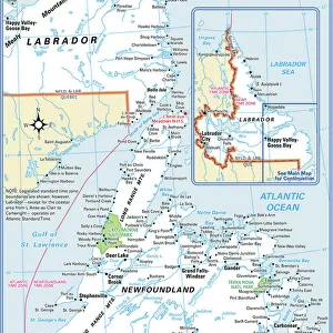
Canvas Print : New Brunswick Nova Scotia map 1884


![]()
Canvas Prints from Fine Art Storehouse
New Brunswick Nova Scotia map 1884
Encyclopedia Britannica 9th Edition New York Charles Scribners and Sonsl 1884 Vol XVII
Unleash your creativity and transform your space into a visual masterpiece!
THEPALMER
Media ID 14756676
© This content is subject to copyright
20"x16" (51x41cm) Canvas Print
Step back in time with our exquisite Canvas Print of the New Brunswick and Nova Scotia Map from ThePalmer, published in the Encyclopedia Britannica 9th Edition in 1884. This vintage map, sourced from the Fine Art Storehouse, showcases intricate detail and historical accuracy. The high-quality canvas print brings a touch of antiquity and charm to any room, making it an ideal addition to your home or office decor. Explore the rich history of these regions with this beautiful and authentic piece of art.
Delivered stretched and ready to hang our premium quality canvas prints are made from a polyester/cotton blend canvas and stretched over a 1.25" (32mm) kiln dried knot free wood stretcher bar. Packaged in a plastic bag and secured to a cardboard insert for safe transit.
Canvas Prints add colour, depth and texture to any space. Professionally Stretched Canvas over a hidden Wooden Box Frame and Ready to Hang
Estimated Product Size is 50.8cm x 40.6cm (20" x 16")
These are individually made so all sizes are approximate
Artwork printed orientated as per the preview above, with landscape (horizontal) orientation to match the source image.
FEATURES IN THESE COLLECTIONS
> Maps and Charts
> Related Images
> North America
> United States of America
> Maps
> North America
> United States of America
> New York
> New York
> Maps
> North America
> United States of America
> New York
> Related Images
> Fine Art Storehouse
> Map
> Historical Maps
> Fine Art Storehouse
> Map
> USA Maps
EDITORS COMMENTS
This print showcases a historical gem, the "New Brunswick Nova Scotia map 1884" sourced from the esteemed Encyclopedia Britannica's 9th Edition. Published in New York by Charles Scribners and Sons in 1884, this exquisite piece of cartographic art takes us on a journey back in time to explore the intricate details of these Canadian provinces. The map itself is a testament to both artistic craftsmanship and meticulous geographical accuracy. Every contour, river, and settlement has been intricately illustrated with precision and care. The fine lines and delicate shading bring life to the landscape, evoking a sense of nostalgia for an era long gone. As we gaze upon this remarkable creation by THEPALMER, we are transported to an age when exploration was paramount, as pioneers sought new frontiers amidst vast wildernesses. It serves as a reminder of how far our understanding of these regions has come since then. Whether you have personal ties to New Brunswick or Nova Scotia or simply appreciate the beauty of vintage maps, this print offers more than just aesthetic pleasure; it invites us to delve into history and discover forgotten stories waiting to be unearthed. With its rich hues and impeccable detailing preserved through Fine Art Storehouse's expert printing techniques, this artwork becomes not only an object for admiration but also an educational tool that allows us to connect with our past while appreciating the skillful artistry behind it.
MADE IN THE USA
Safe Shipping with 30 Day Money Back Guarantee
FREE PERSONALISATION*
We are proud to offer a range of customisation features including Personalised Captions, Color Filters and Picture Zoom Tools
SECURE PAYMENTS
We happily accept a wide range of payment options so you can pay for the things you need in the way that is most convenient for you
* Options may vary by product and licensing agreement. Zoomed Pictures can be adjusted in the Cart.