Canvas Print > Oceania > New Zealand > Maps
Canvas Print : Antique map of New Zealand in the 19th Century, 1873


![]()
Canvas Prints from Fine Art Storehouse
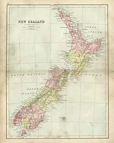
Antique map of New Zealand in the 19th Century, 1873
Vintage engraving of a Antique map of New Zealand in the 19th Century, 1873
Unleash your creativity and transform your space into a visual masterpiece!
duncan1890
Media ID 14069921
© This content is subject to copyright
1870s Auckland Australasia Bad Condition Colour Colours Condition Damaged Dirty Equipment Faded Image Created 1870 1879 Navigational Equipment New Zealand North Island Oceania Retro South Island Stained Styles Supplies Victorian Obsolete
20"x16" (51x41cm) Canvas Print
Discover the captivating history of New Zealand with our vintage Antique Map of New Zealand Canvas Print, created by the talented artist duncan1890 from the Fine Art Storehouse. This exquisite piece, showcasing an engraving from 1873, transports you back in time to the 19th century. Add a touch of history and elegance to your home or office with this stunning and intricately detailed map that is sure to be a conversation starter. Our high-quality canvas prints are meticulously crafted to bring out the rich colors and textures of the original artwork, ensuring a beautiful and long-lasting addition to your space. Embrace the charm of the past with this vintage map of New Zealand.
Delivered stretched and ready to hang our premium quality canvas prints are made from a polyester/cotton blend canvas and stretched over a 1.25" (32mm) kiln dried knot free wood stretcher bar. Packaged in a plastic bag and secured to a cardboard insert for safe transit.
Canvas Prints add colour, depth and texture to any space. Professionally Stretched Canvas over a hidden Wooden Box Frame and Ready to Hang
Estimated Product Size is 40.6cm x 50.8cm (16" x 20")
These are individually made so all sizes are approximate
Artwork printed orientated as per the preview above, with portrait (vertical) orientation to match the source image.
FEATURES IN THESE COLLECTIONS
> Historic
> Historical fashion trends
> Victorian fashion trends
> Historic
> Victorian era fashion
> Maps and Charts
> Related Images
> Oceania
> New Zealand
> Auckland
> Oceania
> New Zealand
> Maps
> Oceania
> New Zealand
> Related Images
> Popular Themes
> North Island
> Fine Art Storehouse
> Map
> Historical Maps
> Fine Art Storehouse
> Top Sellers - Art Prints
EDITORS COMMENTS
This print showcases an antique map of New Zealand, dating back to the 19th century in the year 1873. The vintage engraving beautifully captures the essence of this historical artifact, with its faded colors and worn-out appearance telling tales of a bygone era. Despite its bad condition, this map holds immense value as it represents a significant period in cartography and the exploration of Oceania. The illustration depicts both the North Island and South Island of New Zealand, along with notable regions like Auckland and Westland District. Navigational equipment from that time can be seen scattered across the map, reminding us of how far technology has advanced since then. This old-fashioned lithograph evokes nostalgia for a simpler time when maps were essential tools for navigation. Although stained and damaged over time, this print exudes charm through its aged aesthetic. It serves as a visual portal into history, allowing us to glimpse into what life was like during Victorian times in Australasia. Duncan1890's image created between 1870-1879 perfectly encapsulates the allure of vintage artistry while preserving an important piece of New Zealand's past.
MADE IN THE USA
Safe Shipping with 30 Day Money Back Guarantee
FREE PERSONALISATION*
We are proud to offer a range of customisation features including Personalised Captions, Color Filters and Picture Zoom Tools
SECURE PAYMENTS
We happily accept a wide range of payment options so you can pay for the things you need in the way that is most convenient for you
* Options may vary by product and licensing agreement. Zoomed Pictures can be adjusted in the Cart.