Canvas Print > Arts > Landscape paintings > Waterfall and river artworks > River artworks
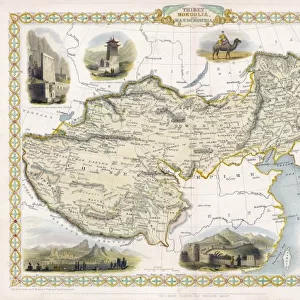
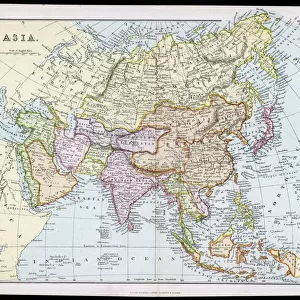
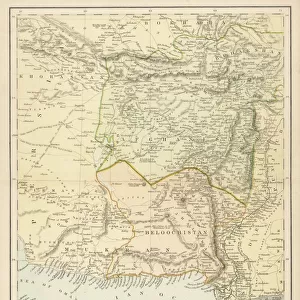
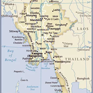
Canvas Print : ASIA MAP, 19th CENTURY. Persia, Afghanistan, Turkestan, India, Tibet, Burma, and Siam


![]()
Canvas Prints from Granger
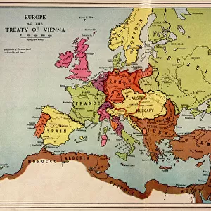
ASIA MAP, 19th CENTURY. Persia, Afghanistan, Turkestan, India, Tibet, Burma, and Siam
ASIA MAP, 19th CENTURY. Persia, Afghanistan, Turkestan, India, Tibet, Burma, and Siam. Detail from a late 19th century map of Asia
Granger holds millions of images spanning more than 25,000 years of world history, from before the Stone Age to the dawn of the Space Age
Media ID 6622175
Afghan Afghanistan Burma Burmese India Indian Ocean Iran Persian Siamese Thailand Tibet Tibetan Turkestan
20"x16" (51x41cm) Canvas Print
"Bring the rich history of Asia into your home with our exquisite Canvas Prints from Media Storehouse. This captivating piece showcases a detailed map of Asia from the late 19th century, featuring countries such as Persia, Afghanistan, Turkestan, India, Tibet, Burma, and Siam. The Granger Collection's "ASIA MAP, 19th CENTURY. Persia, Afghanistan, Turkestan, India, Tibet, Burma, and Siam" is a stunning addition to any room, transporting you on a journey through time. Each Canvas Print is meticulously crafted with premium materials and vibrant colors, ensuring a high-quality and long-lasting piece of art for your home or office. Elevate your decor and ignite your curiosity with Media Storehouse's Canvas Prints."
Delivered stretched and ready to hang our premium quality canvas prints are made from a polyester/cotton blend canvas and stretched over a 1.25" (32mm) kiln dried knot free wood stretcher bar. Packaged in a plastic bag and secured to a cardboard insert for safe transit.
Canvas Prints add colour, depth and texture to any space. Professionally Stretched Canvas over a hidden Wooden Box Frame and Ready to Hang
Estimated Product Size is 50.8cm x 40.6cm (20" x 16")
These are individually made so all sizes are approximate
Artwork printed orientated as per the preview above, with landscape (horizontal) orientation to match the source image.
FEATURES IN THESE COLLECTIONS
> Arts
> Artists
> O
> Oceanic Oceanic
> Arts
> Landscape paintings
> Waterfall and river artworks
> River artworks
> Asia
> Afghanistan
> Maps
> Asia
> Afghanistan
> Related Images
> Asia
> India
> Related Images
> Asia
> Iran
> Related Images
> Asia
> Myanmar
> Related Images
> Granger Art on Demand
> Maps
EDITORS COMMENTS
This print showcases a detailed map of Asia from the 19th century, highlighting various regions including Persia, Afghanistan, Turkestan, India, Tibet, Burma, and Siam. The intricate details on this map provide an intriguing glimpse into the geopolitical landscape of that era. The Persian Empire's vast territory is depicted alongside Afghanistan's rugged terrain and Turkestan's expansive landscapes. Moving eastward, we encounter the vibrant subcontinent of India with its diverse cultures and rich history. Further north lies the mystical land of Tibet with its towering mountains and spiritual heritage. As our eyes wander southwards across the Indian Ocean, we are drawn to Burma's lush forests and ancient temples. Finally, our gaze settles upon Siam (present-day Thailand), known for its majestic palaces and serene rivers. This late 19th-century map not only serves as a visual representation but also evokes a sense of nostalgia for a time when these regions were shrouded in mystery and exploration was at its peak. It reminds us of how borders have shifted over time while preserving traces of their historical significance. With this remarkable piece from The Granger Collection adorning your walls or displayed in your study room, you can embark on an imaginary journey through Asia’s past – tracing trade routes along rivers or imagining expeditions through uncharted territories. Let this exquisite artwork transport you back to an era where curiosity fueled discovery.
MADE IN THE USA
Safe Shipping with 30 Day Money Back Guarantee
FREE PERSONALISATION*
We are proud to offer a range of customisation features including Personalised Captions, Color Filters and Picture Zoom Tools
SECURE PAYMENTS
We happily accept a wide range of payment options so you can pay for the things you need in the way that is most convenient for you
* Options may vary by product and licensing agreement. Zoomed Pictures can be adjusted in the Cart.