Canvas Print > Europe > France > Maps
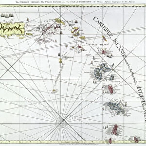
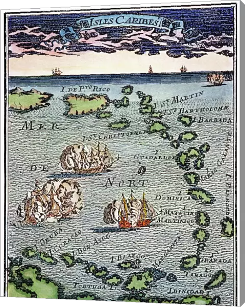
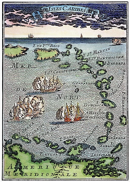
Canvas Print : CARIBBEAN MAP. A map of the Caribbean islands: woodcut, French, c. 1688


![]()
Canvas Prints from Granger
CARIBBEAN MAP. A map of the Caribbean islands: woodcut, French, c. 1688
Granger holds millions of images spanning more than 25,000 years of world history, from before the Stone Age to the dawn of the Space Age
Media ID 7514139
1688 Caribbean Island New World West Indian Wood Cut
20"x16" (51x41cm) Canvas Print
Introducing the captivating Caribbean Map Canvas Print from Media Storehouse, exclusively brought to you by Granger Art on Demand. This exquisite piece showcases an intricately detailed woodcut map of the Caribbean islands, dating back to approximately 1688. The French origins of this historical masterpiece add an air of sophistication and adventure to any space. With the rich, vibrant colors and textures of the canvas print, you'll feel like you've been transported to the heart of the Caribbean. Perfect for history enthusiasts, world travelers, or anyone who appreciates the beauty of vintage cartography, this stunning artwork is sure to be a conversation starter in your home or office. Bring the history and charm of the Caribbean into your living space with the Caribbean Map Canvas Print from Media Storehouse.
Delivered stretched and ready to hang our premium quality canvas prints are made from a polyester/cotton blend canvas and stretched over a 1.25" (32mm) kiln dried knot free wood stretcher bar. Packaged in a plastic bag and secured to a cardboard insert for safe transit.
Canvas Prints add colour, depth and texture to any space. Professionally Stretched Canvas over a hidden Wooden Box Frame and Ready to Hang
Estimated Product Size is 40.6cm x 50.8cm (16" x 20")
These are individually made so all sizes are approximate
Artwork printed orientated as per the preview above, with portrait (vertical) orientation to match the source image.
FEATURES IN THESE COLLECTIONS
> Maps and Charts
> Related Images
> Maps and Charts
> World
> Granger Art on Demand
> Maps
EDITORS COMMENTS
This print showcases a remarkable piece of history - a woodcut map of the Caribbean islands, crafted by French artisans around 1688. The intricate details and delicate engravings on this map transport us back to an era when exploration and colonization were shaping the New World. The map itself is a testament to the skill and artistry of its creators. Every island in the Caribbean archipelago is meticulously depicted, with their unique shapes and sizes accurately portrayed. The French influence is evident in the elegant design elements that adorn the edges of the map, adding a touch of sophistication to this historical artifact. As we gaze upon this vintage treasure, we are reminded of the rich cultural tapestry that defines these islands. From Cuba to Barbados, each landmass represented on this map has its own distinct identity and story waiting to be discovered. Beyond its aesthetic appeal, this woodcut serves as a window into our past. It offers valuable insights into how Europeans perceived and navigated through these uncharted waters centuries ago. It reminds us of the bravery and ambition that drove explorers like Christopher Columbus to venture into unknown territories. In acquiring this print from Granger Art on Demand, we not only bring home a beautiful piece for our collection but also pay homage to those who paved the way for our understanding of geography and history in one corner of our vast world - The Caribbean Islands.
MADE IN THE USA
Safe Shipping with 30 Day Money Back Guarantee
FREE PERSONALISATION*
We are proud to offer a range of customisation features including Personalised Captions, Color Filters and Picture Zoom Tools
SECURE PAYMENTS
We happily accept a wide range of payment options so you can pay for the things you need in the way that is most convenient for you
* Options may vary by product and licensing agreement. Zoomed Pictures can be adjusted in the Cart.