Canvas Print > Arts > Landscape paintings > Waterfall and river artworks > River artworks
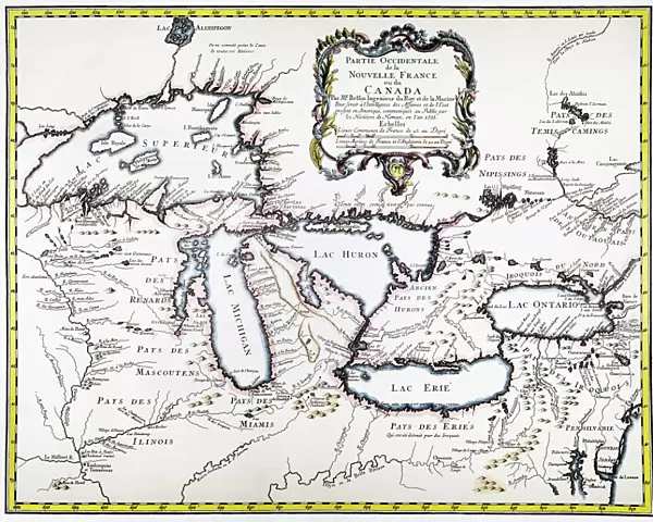
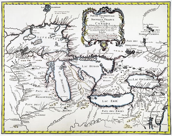
Canvas Print : GREAT LAKES MAP, 1755. French engraved map of the Great Lakes, 1755


![]()
Canvas Prints from Granger
GREAT LAKES MAP, 1755. French engraved map of the Great Lakes, 1755
Granger holds millions of images spanning more than 25,000 years of world history, from before the Stone Age to the dawn of the Space Age
Media ID 6616197
1755 Colonial Great Lakes New France
20"x16" (51x41cm) Canvas Print
"Step back in time with our exquisite Canvas Print of the "GREAT LAKES MAP, 1755" from The Granger Collection. This captivating French engraved map, dating back to 1755, offers a fascinating glimpse into the history of the Great Lakes region. The detailed depiction of the lakes, rivers, and surrounding territories is brought to life with vibrant colors and high-quality craftsmanship. Elevate your home or office decor with this historical masterpiece, perfect for history enthusiasts, cartography lovers, or anyone who appreciates the beauty of the past. Order your Canvas Print today and let this stunning piece tell its story in your space."
Delivered stretched and ready to hang our premium quality canvas prints are made from a polyester/cotton blend canvas and stretched over a 1.25" (32mm) kiln dried knot free wood stretcher bar. Packaged in a plastic bag and secured to a cardboard insert for safe transit.
Canvas Prints add colour, depth and texture to any space. Professionally Stretched Canvas over a hidden Wooden Box Frame and Ready to Hang
Estimated Product Size is 50.8cm x 40.6cm (20" x 16")
These are individually made so all sizes are approximate
Artwork printed orientated as per the preview above, with landscape (horizontal) orientation to match the source image.
FEATURES IN THESE COLLECTIONS
> Arts
> Landscape paintings
> Waterfall and river artworks
> River artworks
> Europe
> France
> Lakes
> Related Images
> Historic
> Colonial America illustrations
> Colonial America
> Maps and Charts
> Related Images
> Granger Art on Demand
> Maps
EDITORS COMMENTS
This print showcases a remarkable piece of history - the "GREAT LAKES MAP, 1755". Crafted by skilled French engravers in the year 1755, this map offers a fascinating glimpse into the colonial era of America. The Great Lakes region is meticulously depicted with intricate details and precision. As we delve into this vintage masterpiece, we are transported back to an era when New France held sway over these vast territories. The map serves as a testament to the exploratory spirit that characterized this time period, as well as the immense geographical knowledge possessed by those intrepid cartographers. The Great Lakes themselves take center stage on this map, their sprawling waters stretching across its surface like shimmering jewels. Each river and tributary is carefully etched onto the paper, emphasizing their vital role in shaping both nature and human settlement. Through studying this French engraved map, one can almost hear echoes of historical events that unfolded along these shores. It invites us to ponder upon indigenous cultures that thrived here long before European colonization began. With its rich hues and delicate lines, this Granger Art on Demand print breathes life into a forgotten chapter of American history. Whether you're an avid historian or simply appreciate artistry from centuries past, let this evocative image transport you to a time when exploration was paramount and new frontiers beckoned adventurers from afar.
MADE IN THE USA
Safe Shipping with 30 Day Money Back Guarantee
FREE PERSONALISATION*
We are proud to offer a range of customisation features including Personalised Captions, Color Filters and Picture Zoom Tools
SECURE PAYMENTS
We happily accept a wide range of payment options so you can pay for the things you need in the way that is most convenient for you
* Options may vary by product and licensing agreement. Zoomed Pictures can be adjusted in the Cart.