Canvas Print > North America > Jamaica > Maps
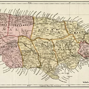
Canvas Print : MAP: JAMAICA, 1755. British map of Jamaica from surveys by Mr. Sheffield, drawn by Patrick Browne


![]()
Canvas Prints from Granger
MAP: JAMAICA, 1755. British map of Jamaica from surveys by Mr. Sheffield, drawn by Patrick Browne
MAP: JAMAICA, 1755.
British map of Jamaica from surveys by Mr. Sheffield, drawn by Patrick Browne, 1755
Granger holds millions of images spanning more than 25,000 years of world history, from before the Stone Age to the dawn of the Space Age
Media ID 12321396
1755 British Browne Island Jamaica Patrick Port Royal Sheffield
30"x20" (76x51cm) Canvas Print
Discover the rich history of Jamaica with our stunning Canvas Print of the 1755 British map of Jamaica. Meticulously crafted from the original Granger, NYC / The Granger Collection, this vintage map showcases intricate details of the island's geography as it appeared over 260 years ago. Drawn by Patrick Browne from surveys by Mr. Sheffield, this historical art piece adds an air of sophistication and intrigue to any room. Bring a piece of the past into your home with our high-quality Canvas Print, expertly printed on premium canvas to ensure vibrant colors and long-lasting durability.
Delivered stretched and ready to hang our premium quality canvas prints are made from a polyester/cotton blend canvas and stretched over a 1.25" (32mm) kiln dried knot free wood stretcher bar. Packaged in a plastic bag and secured to a cardboard insert for safe transit.
Canvas Prints add colour, depth and texture to any space. Professionally Stretched Canvas over a hidden Wooden Box Frame and Ready to Hang
Estimated Product Size is 76.2cm x 50.8cm (30" x 20")
These are individually made so all sizes are approximate
Artwork printed orientated as per the preview above, with landscape (horizontal) orientation to match the source image.
FEATURES IN THESE COLLECTIONS
> Maps and Charts
> Related Images
> North America
> Jamaica
> Maps
> North America
> Jamaica
> Related Images
> Granger Art on Demand
> Maps
EDITORS COMMENTS
This print showcases a historical British map of Jamaica from the year 1755. The map was meticulously crafted by Mr. Sheffield, based on surveys conducted on the island. It was then skillfully drawn by Patrick Browne, who brought this intricate piece to life with his artistic talent. The map provides a fascinating glimpse into Jamaica's past, depicting various landmarks and locations that were significant during that time period. Fort Charles stands proudly in one corner of the map, symbolizing the island's military strength and strategic importance. With its sepia tones and detailed engravings, this print exudes an air of nostalgia and elegance. It transports viewers back to a time when cartography was both an art form and a scientific endeavor. From Port Royal to mid-island regions, every inch of Jamaica is intricately represented on this historic map. The inclusion of text adds further context and information about the different areas depicted. Whether you are a history enthusiast or simply appreciate fine craftsmanship, this print is sure to captivate your imagination. Display it in your home or office as a conversation starter or as a reminder of Jamaica's rich heritage.
MADE IN THE USA
Safe Shipping with 30 Day Money Back Guarantee
FREE PERSONALISATION*
We are proud to offer a range of customisation features including Personalised Captions, Color Filters and Picture Zoom Tools
SECURE PAYMENTS
We happily accept a wide range of payment options so you can pay for the things you need in the way that is most convenient for you
* Options may vary by product and licensing agreement. Zoomed Pictures can be adjusted in the Cart.