Canvas Print > Europe > Russia > Maps
Canvas Print : Atlas of the Yakut ASSR (Autonomous Soviet Socialist Republic). Socialist Yakutia, 1982. Creator: Soviet Union. Glavnoe upravlenie geodezii i kartografii
. Socialist Yakutia, 1982. Creator: Soviet Union. Glavnoe upravlenie geodezii i kartografii")

. Socialist Yakutia, 1982. Creator: Soviet Union. Glavnoe upravlenie geodezii i kartografii")


![]()
Canvas Prints from Heritage Images
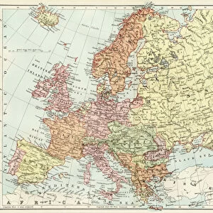
Atlas of the Yakut ASSR (Autonomous Soviet Socialist Republic). Socialist Yakutia, 1982. Creator: Soviet Union. Glavnoe upravlenie geodezii i kartografii
Atlas of the Yakut ASSR (Autonomous Soviet Socialist Republic). Socialist Yakutia, 1982. This atlas was published in 1982 for the commemoration of the 60th anniversary of the formation of the Soviet Union in 1922, of which Yakutia (also seen as Yakutiya and Sakha) was a constituent part from the beginning. The volume thus also served to commemorate the 60th anniversary of the formation of the Yakut Autonomous Soviet Socialist Republic (Yakut ASSR). The ancestral homeland of the Yakut people, this extensive region in northeastern Siberia stretches into the Arctic. The book covers the establishment of Soviet power in the region in the early 1920s and offers a basic geography of the area. It also presents a range of tables on such topics as the local economy, natural resources, levels of education, health care, scientific achievements, local sports, and tourism. A table of contents and a legend for symbols used in the maps is found at the end of the volume. The atlas contains a section on the political exile of several future Soviet leaders (referred to in the text as "Bolshevik-Leninists"
Heritage Images features heritage image collections
Media ID 35129791
© Heritage Art/Heritage Images
1922 1980s Anniversary Arctic Atlas Cartographic Cartography Commemoration Commemorative Cyrillic Economy Eighties Formation Healthcare Map Making Mapmaking Natural Resources Russian State Library Sakha Russia Siberia Siberian Socialist Soviet Union Union Of Soviet Socialist Republics Ussr Yakutia Meeting Of Frontiers Theme
20"x16" (51x41cm) Canvas Print
Step back in time with our captivating Media Storehouse Canvas Print of the Atlas of the Yakut Autonomous Soviet Socialist Republic (ASSR), published in 1982. This vintage atlas, created by the Soviet Union's Glavnoe upravlenie geodezii i kartografii, offers a unique glimpse into the history of Socialist Yakutia. With intricate detail and rich colors, this canvas print is a stunning addition to any home or office decor. Transport yourself to a different era and add a touch of history to your space.
Delivered stretched and ready to hang our premium quality canvas prints are made from a polyester/cotton blend canvas and stretched over a 1.25" (32mm) kiln dried knot free wood stretcher bar. Packaged in a plastic bag and secured to a cardboard insert for safe transit.
Canvas Prints add colour, depth and texture to any space. Professionally Stretched Canvas over a hidden Wooden Box Frame and Ready to Hang
Estimated Product Size is 40.6cm x 50.8cm (16" x 20")
These are individually made so all sizes are approximate
Artwork printed orientated as per the preview above, with portrait (vertical) orientation to match the source image.
FEATURES IN THESE COLLECTIONS
> Europe
> Russia
> Sports
> Related Images
> Maps and Charts
> Early Maps
> Maps and Charts
> Related Images
> Popular Themes
> Russian Leaders
EDITORS COMMENTS
This photograph showcases an atlas titled "Atlas of the Yakut Autonomous Soviet Socialist Republic (ASSR)" published by Glavnoe upravlenie geodezii i kartografii in 1982. The atlas was released in commemoration of the 60th anniversary of the formation of the Soviet Union, of which Yakutia, also known as Yakutiya and Sakha, was a founding constituent part. Spanning the vast, northeastern reaches of Siberia, the Yakut region extends into the Arctic and serves as the ancestral homeland of the Yakut people. The atlas provides a comprehensive overview of the region's history, geography, and development under Soviet rule. It details the establishment of Soviet power in the area during the early 1920s and offers a fundamental understanding of the region's geographical features. Furthermore, the atlas includes various tables on topics such as the local economy, natural resources, education levels, healthcare, scientific advancements, sports, and tourism. An intriguing section in the atlas highlights the political exile of several future Soviet leaders, referred to as Bolshevik-Leninists, within the Yakut region during the Soviet era. The atlas serves as an essential historical record, shedding light on the region's rich history and its role in the larger Soviet Union narrative. This artifact offers a glimpse into the geographical, social, and political landscape of Yakutia during the Soviet era, making it an invaluable resource for researchers, historians, and those interested in the history of the Soviet Union and its constituent regions.
MADE IN THE USA
Safe Shipping with 30 Day Money Back Guarantee
FREE PERSONALISATION*
We are proud to offer a range of customisation features including Personalised Captions, Color Filters and Picture Zoom Tools
SECURE PAYMENTS
We happily accept a wide range of payment options so you can pay for the things you need in the way that is most convenient for you
* Options may vary by product and licensing agreement. Zoomed Pictures can be adjusted in the Cart.