Canvas Print > Europe > Portugal > Maps
Canvas Print : Map of Afrique showing Possessions et protectorats d'Europe, 1914. Creator: Unknown


![]()
Canvas Prints from Heritage Images
Map of Afrique showing Possessions et protectorats d'Europe, 1914. Creator: Unknown
Map of Afrique showing Possessions et protectorats d'Europe, 1914. From "Grande Geographie Bong Illustree", 1914
Heritage Images features heritage image collections
Media ID 36294489
© The Print Collector/Heritage Images
Belgian Border Borders Cartography Colonies Colony Map Making Mapmaking Portugal Portuguese Scramble For Africa Countries
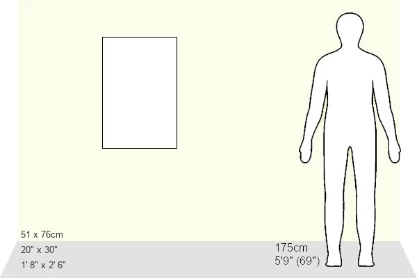
30"x20" (76x51cm) Canvas Print
Step back in time with our exclusive Media Storehouse Canvas Print featuring a historic map of Africa from 1914. This captivating vintage map, sourced from Heritage Images, showcases Europe's possessions and protectorates in Africa during that era. Add an element of history and world culture to your home or office décor with this beautifully printed canvas, showcasing intricate details and vibrant colors. Perfect for history enthusiasts, geography buffs, or anyone looking to add a touch of the past to their space. Unknown creator, but the story this map tells is sure to spark conversation.
Delivered stretched and ready to hang our premium quality canvas prints are made from a polyester/cotton blend canvas and stretched over a 1.25" (32mm) kiln dried knot free wood stretcher bar. Packaged in a plastic bag and secured to a cardboard insert for safe transit.
Canvas Prints add colour, depth and texture to any space. Professionally Stretched Canvas over a hidden Wooden Box Frame and Ready to Hang
Estimated Product Size is 50.8cm x 76.2cm (20" x 30")
These are individually made so all sizes are approximate
Artwork printed orientated as per the preview above, with portrait (vertical) orientation to match the source image.
FEATURES IN THESE COLLECTIONS
> Europe
> Belgium
> Related Images
> Europe
> Portugal
> Related Images
EDITORS COMMENTS
This vintage map print, titled "Map of Afrique showing Possessions et protectorats d'Europe" from the 1914 issue of "Grande Geographie Bong Illustree," showcases the European colonies and protectorates in Africa during the early 20th century. The intricate engraving reveals the extensive reach of European powers across the African continent, with territories claimed by Belgium, Britain, France, Germany, Italy, Portugal, and Spain meticulously delineated. The map serves as a poignant reminder of the "Scramble for Africa," a period of intense competition among European nations to claim and control African territories, primarily driven by economic and strategic interests. The bold colors and clear borders on the map underscore the definitive nature of European colonization during this era. The map's creation in 1914 places it within the context of the late colonial period, a time when European powers were consolidating their hold on their African territories and preparing for the challenges of the 20th century. The map's intricate detail and artistic merit make it an invaluable historical artifact, shedding light on a pivotal moment in world history. The map's provenance is unknown, but it is believed to have been published by "Grande Geographie Bong Illustree," a renowned French geography magazine of the time. The map's age and historical significance make it a fascinating addition to any collection of historical maps or Africana, and a captivating conversation starter for those interested in the history of colonialism and cartography.
MADE IN THE USA
Safe Shipping with 30 Day Money Back Guarantee
FREE PERSONALISATION*
We are proud to offer a range of customisation features including Personalised Captions, Color Filters and Picture Zoom Tools
SECURE PAYMENTS
We happily accept a wide range of payment options so you can pay for the things you need in the way that is most convenient for you
* Options may vary by product and licensing agreement. Zoomed Pictures can be adjusted in the Cart.