Canvas Print > Europe > United Kingdom > England > London > Sights > British Museum
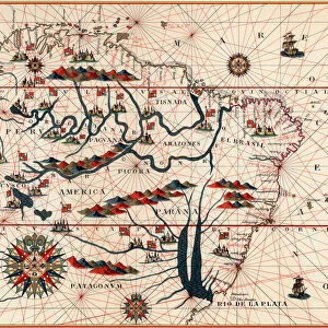
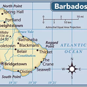
Canvas Print : Map of Barbados, 1683


![]()
Canvas Prints from Heritage Images
Map of Barbados, 1683
Map of Barbados, 1683. Barbados was first settled by the British in 1627. From the British Museum
Heritage Images features heritage image collections
Media ID 14845997
© Ann Ronan Picture Library / Heritage-Images
Barbados Caribbean Cartography Chart Colony Indies Island Map Making Navigation West Indies Ann Ronan Pictures
20"x16" (51x41cm) Canvas Print
Discover the rich history of Barbados with our exquisite Canvas Print of the rare 1683 map, originally from the British Museum. This captivating vintage map, depicting the island of Barbados as it was known over 300 years ago, is a true treasure from Heritage Images. The intricate details of the map are brought to life with our premium canvas printing process, creating a stunning piece of art that adds character and depth to any room. Perfect for history enthusiasts and those who appreciate the beauty of the past, this Canvas Print makes a unique and thoughtful gift. Bring a piece of the past into your home with Media Storehouse's Canvas Print of the 1683 Map of Barbados.
Delivered stretched and ready to hang our premium quality canvas prints are made from a polyester/cotton blend canvas and stretched over a 1.25" (32mm) kiln dried knot free wood stretcher bar. Packaged in a plastic bag and secured to a cardboard insert for safe transit.
Canvas Prints add colour, depth and texture to any space. Professionally Stretched Canvas over a hidden Wooden Box Frame and Ready to Hang
Estimated Product Size is 40.6cm x 50.8cm (16" x 20")
These are individually made so all sizes are approximate
Artwork printed orientated as per the preview above, with portrait (vertical) orientation to match the source image.
FEATURES IN THESE COLLECTIONS
> Europe
> United Kingdom
> England
> London
> Sights
> British Museum
> Maps and Charts
> Related Images
> North America
> Barbados
> Maps
> North America
> Barbados
> Related Images
EDITORS COMMENTS
This print showcases a historical treasure - the Map of Barbados from 1683. Created by an unknown cartographer, this map offers a fascinating glimpse into the colonial era and British exploration in the West Indies during the 17th century. Barbados, a stunning island located in the Caribbean Sea, was first settled by the British in 1627. This map serves as a testament to their early presence and influence on this tropical paradise. The intricate details and vibrant colors bring to life its geographical features, highlighting its position within the West Indies. As we examine this piece of artistry, we are transported back in time to an era when navigation relied heavily on maps like these. It is remarkable how such maps were meticulously crafted without modern technology or satellite imagery. The Map of Barbados not only represents colonialism but also symbolizes adventure and discovery. Its existence reminds us of Britain's expansive maritime empire during that period. Preserved at the prestigious British Museum, this print allows us to appreciate both its historical significance and artistic beauty. Thanks to Ann Ronan Pictures for capturing this image with utmost precision and attention to detail. Whether you are fascinated by history or simply captivated by exquisite cartography, this print is sure to ignite your imagination as you explore Barbados through centuries past.
MADE IN THE USA
Safe Shipping with 30 Day Money Back Guarantee
FREE PERSONALISATION*
We are proud to offer a range of customisation features including Personalised Captions, Color Filters and Picture Zoom Tools
SECURE PAYMENTS
We happily accept a wide range of payment options so you can pay for the things you need in the way that is most convenient for you
* Options may vary by product and licensing agreement. Zoomed Pictures can be adjusted in the Cart.