Canvas Print > Europe > France > Paris > Maps
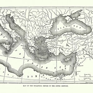
Canvas Print : Map of the Byzantine Empire in the Ninth Century, 1890. Creator: Unknown


![]()
Canvas Prints from Heritage Images
Map of the Byzantine Empire in the Ninth Century, 1890. Creator: Unknown
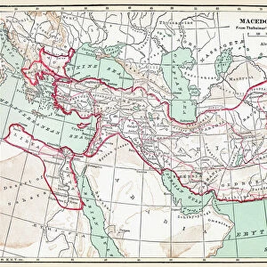
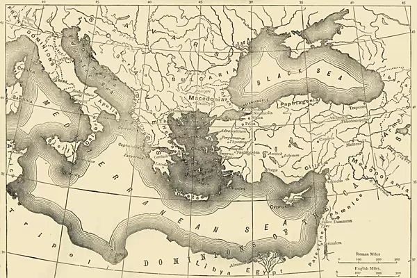
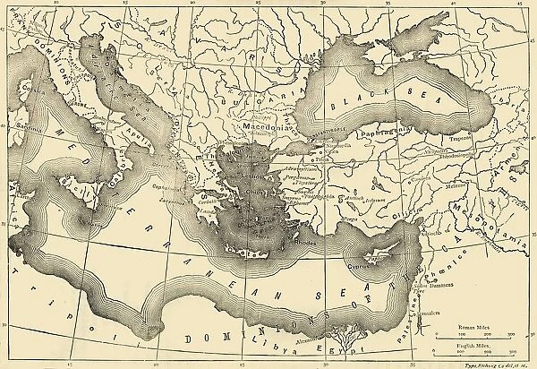
Map of the Byzantine Empire in the Ninth Century, 1890. The Byzantine Empire underwent a revival under Macedonian emperors from Basil I (867-886) in late 9th, 10th, and early 11th centuries. From " Cassells Illustrated Universal History, Vol. III - The Middle Ages", by Edmund Ollier. [Cassell and Company, Limited, London, Paris and Melbourne, 1890. ]
Heritage Images features heritage image collections
Media ID 19127365
© The Print Collector/Heritage Images
9th Century Basil Black Sea Byzantine Byzantium Cassells Cassells Illustrated Universal History Co Cassell Control Edmund Edmund Ollier Macedonia Macedonian Middle Eastern Ollier Ollier Edmund Territorial Territory Cassell And Company Ltd
30"x20" (76x51cm) Canvas Print
Step back in time with our exquisite Canvas Print of the Byzantine Empire Map from the ninth century, 1890. This captivating historical art piece, sourced from Heritage Images, showcases the Byzantine Empire's expansion during the Macedonian dynasty, with emperors Basil I (867-886) leading the revival in the late ninth, 10th, and early 11th centuries. Add an air of sophistication and intrigue to your home or office decor with this beautifully detailed, unknown creator's masterpiece, now available as a Canvas Print from Media Storehouse.
Delivered stretched and ready to hang our premium quality canvas prints are made from a polyester/cotton blend canvas and stretched over a 1.25" (32mm) kiln dried knot free wood stretcher bar. Packaged in a plastic bag and secured to a cardboard insert for safe transit.
Canvas Prints add colour, depth and texture to any space. Professionally Stretched Canvas over a hidden Wooden Box Frame and Ready to Hang
Estimated Product Size is 76.2cm x 50.8cm (30" x 20")
These are individually made so all sizes are approximate
Artwork printed orientated as per the preview above, with landscape (horizontal) orientation to match the source image.
FEATURES IN THESE COLLECTIONS
> Arts
> Art Movements
> Medieval Art
> Arts
> Literature
> Europe
> France
> Paris
> Maps
> Europe
> Macedonia
> Posters
> Europe
> Macedonia
> Related Images
> Maps and Charts
> Early Maps
> Maps and Charts
> North Macedonia
> Maps and Charts
> Related Images
EDITORS COMMENTS
This print showcases a remarkable piece of history - the Map of the Byzantine Empire in the Ninth Century, created in 1890 by an unknown artist. The Byzantine Empire experienced a renaissance during the reign of Macedonian emperors, particularly under Basil I from 867 to 886. This map beautifully illustrates their territorial control and influence over vast regions. From "Cassells Illustrated Universal History, Vol. III - The Middle Ages" by Edmund Ollier, this antique engraving offers a close-up view of the empire's geographical features and boundaries. It takes us back to a time when literature, art, and architecture flourished under Byzantium's rule. The monochrome aesthetic adds an air of mystery and nostalgia to this historical artifact. As we examine every detail on this intricate map, we can't help but marvel at its significance in understanding medieval times. While the creator remains anonymous, their work stands as a testament to human curiosity about our past. This print serves as both an educational tool for those interested in geography and history enthusiasts alike. Whether displayed in libraries or private collections, this photograph invites viewers into an era long gone but not forgotten – where empires rose and fell against the backdrop of political intrigue and cultural exchange across Europe and Asia Minor.
MADE IN THE USA
Safe Shipping with 30 Day Money Back Guarantee
FREE PERSONALISATION*
We are proud to offer a range of customisation features including Personalised Captions, Color Filters and Picture Zoom Tools
SECURE PAYMENTS
We happily accept a wide range of payment options so you can pay for the things you need in the way that is most convenient for you
* Options may vary by product and licensing agreement. Zoomed Pictures can be adjusted in the Cart.