Canvas Print > Asia > Turkey > Related Images
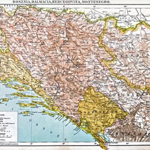
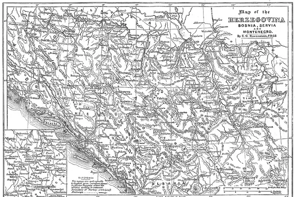
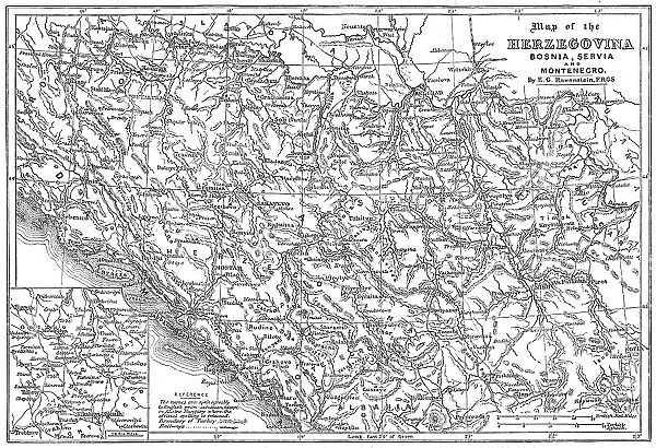
Canvas Print : Map of the Herzegovina, Bosnia, Servia and Montenegro, 1876. Creator: Unknown


![]()
Canvas Prints from Heritage Images
Map of the Herzegovina, Bosnia, Servia and Montenegro, 1876. Creator: Unknown
Map of the Herzegovina, Bosnia, Servia and Montenegro, 1876. Map showing the theatre of war of the Herzegovina Uprising. Reference: The names are spelt agreably to English pronunciation, except in Austro-Hungary where the official spelling is retained'. Boundary of Turkey and railways are shown. By E. G. Ravenstein. From "Illustrated London News", 1876
Heritage Images features heritage image collections
Media ID 36367487
© The Print Collector/Heritage Images
Adriatic Adriatic Sea Balkans Bosnia Bosnia And Herzegovina Bosnian Hercegovina Herzegovina Herzegovina Uprising Montenegro Sarajevo Bosnia And Hercegovina Serbia Serbia And Montenegro Serbia Yugoslavia Uprising
30"x20" (76x51cm) Canvas Print
Step back in time with our vintage Canvas Print of a historical map from Heritage Images. This intriguing piece showcases the political landscape of Herzegovina, Bosnia, Serbia, and Montenegro as it appeared in 1876. The map, created by an unknown artist, offers a unique glimpse into the theatre of war during the Herzegovina Uprising. Add a touch of history and culture to your home or office decor with this captivating Canvas Print.
Delivered stretched and ready to hang our premium quality canvas prints are made from a polyester/cotton blend canvas and stretched over a 1.25" (32mm) kiln dried knot free wood stretcher bar. Packaged in a plastic bag and secured to a cardboard insert for safe transit.
Canvas Prints add colour, depth and texture to any space. Professionally Stretched Canvas over a hidden Wooden Box Frame and Ready to Hang
Estimated Product Size is 76.2cm x 50.8cm (30" x 20")
These are individually made so all sizes are approximate
Artwork printed orientated as per the preview above, with landscape (horizontal) orientation to match the source image.
FEATURES IN THESE COLLECTIONS
> Asia
> Turkey
> Related Images
> Europe
> Bosnia and Herzegovina
> Maps
> Europe
> Bosnia and Herzegovina
> Railways
> Europe
> Bosnia and Herzegovina
> Sarajevo
> Europe
> Croatia
> Related Images
EDITORS COMMENTS
This black and white map print, dating back to 1876, showcases the regions of Herzegovina, Bosnia, Serbia, and Montenegro during a pivotal moment in history - the Herzegovina Uprising. The map, created by an unknown artist, was published in the prestigious "Illustrated London News," and was produced by E.G. Ravenstein. The map provides a detailed geographical representation of the area, with the Adriatic Sea and its surrounding coastline prominently featured. The boundary between Turkey and the regions in question is clearly demarcated, as are the railways that crisscrossed the landscape. The names of the countries and regions are spelled according to English pronunciation, except for those under Austro-Hungarian rule, where the official spelling is retained. The map serves as a snapshot of the political landscape during a time of great upheaval. The Herzegovina Uprising, also known as the Herzegovina Revolution, was a rebellion against the Ottoman Empire that lasted from 1875 to 1878. The conflict saw the involvement of various European powers, including Britain, and ultimately led to the formation of Serbia and Montenegro as independent states. The map's intricate details and historical significance make it a valuable addition to any collection of historical maps or European geography. From the bustling port city of Dubrovnik in Dubrovnik-Neretva County, Croatia, to the mountainous terrain of Montenegro and the capital cities of Sarajevo in Bosnia and Herzegovina and Belgrade in Serbia, this map offers a glimpse into the complex political landscape of the late 19th century Balkans.
MADE IN THE USA
Safe Shipping with 30 Day Money Back Guarantee
FREE PERSONALISATION*
We are proud to offer a range of customisation features including Personalised Captions, Color Filters and Picture Zoom Tools
FREE COLORIZATION SERVICE
You can choose advanced AI Colorization for this picture at no extra charge!
SECURE PAYMENTS
We happily accept a wide range of payment options so you can pay for the things you need in the way that is most convenient for you
* Options may vary by product and licensing agreement. Zoomed Pictures can be adjusted in the Cart.