Canvas Print > Europe > United Kingdom > Scotland > Edinburgh > Edinburgh
Canvas Print : Map of Madras, Hyderabad, Mysore, Coorg and Ceylon, 1902. Creator: Unknown


![]()
Canvas Prints from Heritage Images
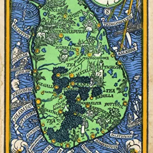
Map of Madras, Hyderabad, Mysore, Coorg and Ceylon, 1902. Creator: Unknown
Map of Madras, Hyderabad, Mysore, Coorg and Ceylon, 1902. From The Century Atlas of the World. [John Walker & Co, Ltd. London, 1902]
Heritage Images features heritage image collections
Media ID 15512302
© The Print Collector / Heritage-Images
Andhra Pradesh British Raj Ceylon Chennai Edinburgh Geographical Institute Hyderabad Karnataka Madras Mysore Sri Lanka Tamil Nadu The Raj British Empire Hindoostan
20"x16" (51x41cm) Canvas Print
Step back in time with our exquisite Canvas Print of the Map of Madras, Hyderabad, Mysore, Coorg, and Ceylon from 1902. This vintage map, sourced from Heritage Images, showcases the historical geography of South India and Sri Lanka as depicted in The Century Atlas of the World by John Walker & Co. Ltd. London. The intricate details and authentic colors are beautifully rendered on high-quality canvas, making it a stunning addition to your home or office decor. Relive the history and charm of the past with this unique and captivating piece.
Delivered stretched and ready to hang our premium quality canvas prints are made from a polyester/cotton blend canvas and stretched over a 1.25" (32mm) kiln dried knot free wood stretcher bar. Packaged in a plastic bag and secured to a cardboard insert for safe transit.
Canvas Prints add colour, depth and texture to any space. Professionally Stretched Canvas over a hidden Wooden Box Frame and Ready to Hang
Estimated Product Size is 40.6cm x 50.8cm (16" x 20")
These are individually made so all sizes are approximate
Artwork printed orientated as per the preview above, with portrait (vertical) orientation to match the source image.
FEATURES IN THESE COLLECTIONS
> Asia
> India
> Related Images
> Asia
> Sri Lanka
> Related Images
> Europe
> United Kingdom
> Scotland
> Edinburgh
> Edinburgh
> Europe
> United Kingdom
> Scotland
> Lothian
> Edinburgh
> Maps and Charts
> British Empire Maps
> Maps and Charts
> India
EDITORS COMMENTS
This print showcases a Map of Madras, Hyderabad, Mysore, Coorg and Ceylon from the year 1902. The creator of this remarkable piece remains unknown but it was featured in The Century Atlas of the World by John Walker & Co, Ltd. London. The map takes us back to the early 20th century during the time when India was under British rule. It provides a visual representation of several regions including Andhra Pradesh, Tamil Nadu, Karnataka, and Sri Lanka (formerly known as Ceylon). With vibrant colors and intricate details, it offers a glimpse into the geographical boundaries and locations within these areas. As we explore this historical artifact further, we can't help but marvel at how it reflects an era when colonial powers had significant influence over vast territories across Hindoostan (India). This map serves as a reminder of both the British Raj's control over these regions and their efforts to document and understand their dominions. Preserved by The Print Collector in impeccable condition for future generations to appreciate its significance in our shared heritage. Let us cherish this snapshot from history that not only captures cartographic excellence but also represents an important chapter in India's past - one that shaped its present-day geography and cultural diversity.
MADE IN THE USA
Safe Shipping with 30 Day Money Back Guarantee
FREE PERSONALISATION*
We are proud to offer a range of customisation features including Personalised Captions, Color Filters and Picture Zoom Tools
SECURE PAYMENTS
We happily accept a wide range of payment options so you can pay for the things you need in the way that is most convenient for you
* Options may vary by product and licensing agreement. Zoomed Pictures can be adjusted in the Cart.