Canvas Print > Arts > Artists > P > Polynesian Polynesian
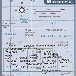
Canvas Print : Map of the Pacific Ocean, c1910s. Artist: Emery Walker Ltd


![]()
Canvas Prints from Heritage Images
Map of the Pacific Ocean, c1910s. Artist: Emery Walker Ltd
Map of the Pacific Ocean, c1910s
Heritage Images features heritage image collections
Media ID 14992231
Border Circle Division Emery Emery Walker Emery Walker Ltd Emery Walker Sc Melanesia Micronesia Pacific Islands Pacific Ocean Polynesia Polynesian Sir Emery Walker Walker Inset Micronesian
20"x16" (51x41cm) Canvas Print
Step back in time with our exquisite Canvas Print of the Pacific Ocean Map from Emery Walker Ltd, dated back to the 1910s. This vintage map, sourced from Heritage Images, showcases intricate details of the Pacific Ocean during an era of exploration and discovery. The high-quality canvas print brings history to life in your home or office, with vibrant colors and sharp details that truly capture the essence of this historical artifact. Perfect for maritime enthusiasts, history buffs, or anyone who appreciates the beauty of vintage maps, this Canvas Print is sure to make a statement and ignite conversation. Order yours today and add a touch of history to your space.
Delivered stretched and ready to hang our premium quality canvas prints are made from a polyester/cotton blend canvas and stretched over a 1.25" (32mm) kiln dried knot free wood stretcher bar. Packaged in a plastic bag and secured to a cardboard insert for safe transit.
Canvas Prints add colour, depth and texture to any space. Professionally Stretched Canvas over a hidden Wooden Box Frame and Ready to Hang
Estimated Product Size is 50.8cm x 40.6cm (20" x 16")
These are individually made so all sizes are approximate
Artwork printed orientated as per the preview above, with landscape (horizontal) orientation to match the source image.
FEATURES IN THESE COLLECTIONS
> Arts
> Artists
> O
> Oceanic Oceanic
> Arts
> Artists
> P
> Polynesian Polynesian
> Maps and Charts
> Related Images
> Oceania
> Federated States of Micronesia
> Maps
EDITORS COMMENTS
This close-up of a color print, titled "Map of the Pacific Ocean, c1910s" takes us on a journey through time and space. Created by Emery Walker Ltd, this exquisite piece of art showcases the beauty and intricacy of cartography in the early 20th century. The map's vibrant colors immediately draw our attention to its central feature: the vast expanse of the Pacific Ocean. As we explore further, we notice how it skillfully divides Melanesia, Polynesia, and Micronesia into distinct regions with intricate borders. Each island group is represented as a small circle within this expansive blue canvas. The artist's attention to detail becomes evident when we examine the inset sections that provide additional information about specific locations within these Pacific islands. These insets offer glimpses into various cultures and communities thriving amidst this oceanic paradise. As we delve deeper into this historical artifact, it becomes clear that Sir Emery Walker was not only an engraver but also an explorer at heart. Through his meticulous craftsmanship, he invites us to embark on our own voyage across time and space – from his era in the 1910s back to centuries past when these islands were first discovered. This stunning print captures both the scientific precision required for accurate mapping and the artistic flair necessary to evoke wonderment in those who behold it. It serves as a testament to human curiosity about distant lands while reminding us of their interconnectedness within one magnificent body of water – The Pacific Ocean.
MADE IN THE USA
Safe Shipping with 30 Day Money Back Guarantee
FREE PERSONALISATION*
We are proud to offer a range of customisation features including Personalised Captions, Color Filters and Picture Zoom Tools
SECURE PAYMENTS
We happily accept a wide range of payment options so you can pay for the things you need in the way that is most convenient for you
* Options may vary by product and licensing agreement. Zoomed Pictures can be adjusted in the Cart.