Canvas Print > North America > Saint Lucia > Maps
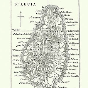
Canvas Print : A map of St Lucia, the West Indies, 1758. Artist: N Bellun


![]()
Canvas Prints from Heritage Images
A map of St Lucia, the West Indies, 1758. Artist: N Bellun
A map of St Lucia, the West Indies, 1758
Heritage Images features heritage image collections
Media ID 14936008
© The Print Collector / Heritage-Images
Caribbean Copperplate Gulf Gulf Of Mexico Indies Island Lesser Antilles Saint Lucia St Lucia West Indian West Indies Windward Islands
30"x20" (76x51cm) Canvas Print
Add a touch of history to your home or office with our stunning Canvas Print of "A Map of St Lucia, The West Indies, 1758" by N Bellun, from Heritage Images. This exquisite map provides a captivating glimpse into the past, depicting the political boundaries of St Lucia during the year 1758. The intricate details and vibrant colors come alive when brought to life on a high-quality canvas print. Perfect for history enthusiasts, world travelers, or those who appreciate the beauty of antique maps, this unique piece is sure to make a statement in any space. Order now and let the story of St Lucia unfold in your home.
Delivered stretched and ready to hang our premium quality canvas prints are made from a polyester/cotton blend canvas and stretched over a 1.25" (32mm) kiln dried knot free wood stretcher bar. Packaged in a plastic bag and secured to a cardboard insert for safe transit.
Canvas Prints add colour, depth and texture to any space. Professionally Stretched Canvas over a hidden Wooden Box Frame and Ready to Hang
Estimated Product Size is 76.2cm x 50.8cm (30" x 20")
These are individually made so all sizes are approximate
Artwork printed orientated as per the preview above, with landscape (horizontal) orientation to match the source image.
FEATURES IN THESE COLLECTIONS
> Maps and Charts
> Related Images
> North America
> Mexico
> Maps
> North America
> Mexico
> Related Images
> North America
> Saint Lucia
> Maps
> North America
> Saint Lucia
> Related Images
EDITORS COMMENTS
This print takes us back in time to the year 1758, showcasing a meticulously detailed map of St Lucia, one of the enchanting islands nestled in the West Indies. Created by the talented artist N Bellun, this copperplate engraving offers a glimpse into the geographical features that define this Caribbean gem. The map highlights St Lucia's strategic location within the West Indies, situated amidst the azure waters of the Gulf of Mexico. Its inclusion among the Lesser Antilles and Windward Islands further emphasizes its significance in regional geography. Every contour and coastline is intricately etched on this monochrome masterpiece, allowing viewers to appreciate both its artistic beauty and informative value. As we explore this historic cartographic treasure, it becomes evident that N Bellun possessed an exceptional skill for capturing intricate details with precision. The print transports us to an era when maps were not only functional tools but also works of art. Whether you are a history enthusiast or simply captivated by St Lucia's allure, this print serves as a visual gateway to immerse yourself in its rich past. Let your imagination wander through time as you trace each line on this exquisite piece from Heritage Images' collection - a testament to N Bellun's talent and dedication to preserving our world's geographic heritage.
MADE IN THE USA
Safe Shipping with 30 Day Money Back Guarantee
FREE PERSONALISATION*
We are proud to offer a range of customisation features including Personalised Captions, Color Filters and Picture Zoom Tools
SECURE PAYMENTS
We happily accept a wide range of payment options so you can pay for the things you need in the way that is most convenient for you
* Options may vary by product and licensing agreement. Zoomed Pictures can be adjusted in the Cart.