Canvas Print > Arts > Artists > H > Jodocus Hondius
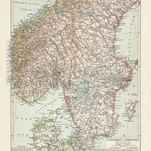
Canvas Print : Nova Poloniae delineation (Map of Poland), c. 1629-1630. Artist: Hondius, Jodocus (1563-1612)
, c. 1629-1630. Artist: Hondius, Jodocus (1563-1612)")

, c. 1629-1630. Artist: Hondius, Jodocus (1563-1612)")


![]()
Canvas Prints from Heritage Images
Nova Poloniae delineation (Map of Poland), c. 1629-1630. Artist: Hondius, Jodocus (1563-1612)
Nova Poloniae delineation (Map of Poland), c. 1629-1630. From a private collection
Heritage Images features heritage image collections
Media ID 14893670
© Fine Art Images
Cartography Hondius Poland Sigismund Iii Sigismund Iii Of Poland Sigismund Iii Vasa Zygmunt Iii Waza
20"x16" (51x41cm) Canvas Print
Discover the rich history of Poland with our exquisite Canvas Print of the Nova Poloniae Delineation map, created by renowned cartographer Jodocus Hondius around 1629-1630. This captivating vintage map showcases intricate details of Poland during that era, making it a stunning addition to your home or office decor. Our high-quality Canvas Prints are meticulously crafted to bring out the vibrant colors and sharp details of this Heritage Image, ensuring a breathtaking display that will surely be a conversation starter.
Delivered stretched and ready to hang our premium quality canvas prints are made from a polyester/cotton blend canvas and stretched over a 1.25" (32mm) kiln dried knot free wood stretcher bar. Packaged in a plastic bag and secured to a cardboard insert for safe transit.
Canvas Prints add colour, depth and texture to any space. Professionally Stretched Canvas over a hidden Wooden Box Frame and Ready to Hang
Estimated Product Size is 50.8cm x 40.6cm (20" x 16")
These are individually made so all sizes are approximate
Artwork printed orientated as per the preview above, with landscape (horizontal) orientation to match the source image.
FEATURES IN THESE COLLECTIONS
> Arts
> Artists
> H
> Jodocus Hondius
> Europe
> Poland
> Related Images
> Europe
> Sweden
> Related Images
> Maps and Charts
> Related Images
EDITORS COMMENTS
This print showcases the "Nova Poloniae delineation (Map of Poland)" created by the talented artist Jodocus Hondius. Crafted between 1629 and 1630, this exquisite map offers a glimpse into the rich history and cartography of Poland. From a private collection, it is an invaluable piece that captures the essence of this era. The intricate details on this map highlight not only Poland but also its neighboring countries such as Sweden and Flanders. Through expert etching and graphic arts techniques, Hondius brings to life the geographical features and boundaries of these regions. One cannot help but be drawn to Sigismund III Vasa, who ruled over Poland during this time period. Known as Zygmunt III Waza in Polish, he played a significant role in shaping Polish history. The inclusion of his name adds historical context to this remarkable artwork. Hondius' skillful execution elevates this piece from mere cartography to fine art. The precision with which he depicts each element demonstrates his mastery in capturing both accuracy and aesthetic appeal. As we gaze upon this photo print, we are transported back in time - immersed in a world where maps were meticulously crafted by hand, serving as vital tools for exploration and understanding. This stunning representation serves as a testament to the enduring power of artistry combined with historical significance
MADE IN THE USA
Safe Shipping with 30 Day Money Back Guarantee
FREE PERSONALISATION*
We are proud to offer a range of customisation features including Personalised Captions, Color Filters and Picture Zoom Tools
SECURE PAYMENTS
We happily accept a wide range of payment options so you can pay for the things you need in the way that is most convenient for you
* Options may vary by product and licensing agreement. Zoomed Pictures can be adjusted in the Cart.