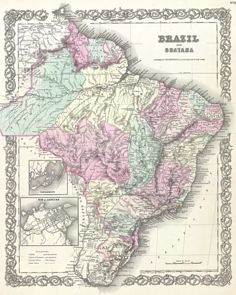
Canvas Print : 1855, Colton Map of Brazil and Guyana, topography, cartography, geography, land, illustration


![]()
Canvas Prints from Liszt Collection
1855, Colton Map of Brazil and Guyana, topography, cartography, geography, land, illustration
1855, Colton Map of Brazil and Guyana
Liszt Collection of nineteenth-century engravings and images to browse and enjoy
Media ID 14007456
© Artokoloro Quint Lox Limited
1855 Antique Map Latitude Longitude Mappa Mundi Old Antique Plan Old Antique View Ols Antique Map Rare Old Maps Topo
20"x16" (51x41cm) Canvas Print
Discover the rich history and intricate detail of the 1855 Colton Map of Brazil and Guyana, now available as a stunning Canvas Print from Media Storehouse. Originating from the renowned Liszt Collection, this captivating map showcases the topography, cartography, and geography of South America's largest countries. The illustration, featuring lush landscapes, rivers, and borders, is beautifully preserved in this high-quality canvas print. Elevate your home or office decor with this unique and educational piece, perfect for history enthusiasts, geography buffs, or anyone who appreciates the beauty of antique maps. Bring the past to life and create a conversation starter with this exquisite Canvas Print from Media Storehouse.
Delivered stretched and ready to hang our premium quality canvas prints are made from a polyester/cotton blend canvas and stretched over a 1.25" (32mm) kiln dried knot free wood stretcher bar. Packaged in a plastic bag and secured to a cardboard insert for safe transit.
Canvas Prints add colour, depth and texture to any space. Professionally Stretched Canvas over a hidden Wooden Box Frame and Ready to Hang
Estimated Product Size is 40.6cm x 50.8cm (16" x 20")
These are individually made so all sizes are approximate
Artwork printed orientated as per the preview above, with portrait (vertical) orientation to match the source image.
EDITORS COMMENTS
This print showcases the intricate beauty of the "1855, Colton Map of Brazil and Guyana". A true masterpiece in topography, cartography, and geography, this map takes us on a visual journey through the land. Its detailed illustrations transport us to a bygone era when exploration and discovery were at their peak. The vintage charm of this ancient map is evident in its aged paper texture and retro aesthetic. It serves as a window into history, reminding us of the rich cultural heritage that lies within these regions. The decorative elements add an artistic touch to this historical artifact, making it not just a navigational tool but also an exquisite piece of art. As we gaze upon this rare old map, we are reminded of the importance of geographical knowledge in understanding our world's past. The grid-like structure with latitude and longitude lines gives us a sense of order amidst the vastness of Earth's landscapes. It evokes feelings of wonderment about how explorers from centuries ago used such maps to navigate uncharted territories. Whether you are an avid traveler or simply fascinated by history, this Colton Map offers a glimpse into another time and space. With its meticulous details capturing every region with precision, it invites us to explore Brazil and Guyana through the eyes of those who first mapped them out over 150 years ago.
MADE IN THE USA
Safe Shipping with 30 Day Money Back Guarantee
FREE PERSONALISATION*
We are proud to offer a range of customisation features including Personalised Captions, Color Filters and Picture Zoom Tools
SECURE PAYMENTS
We happily accept a wide range of payment options so you can pay for the things you need in the way that is most convenient for you
* Options may vary by product and licensing agreement. Zoomed Pictures can be adjusted in the Cart.