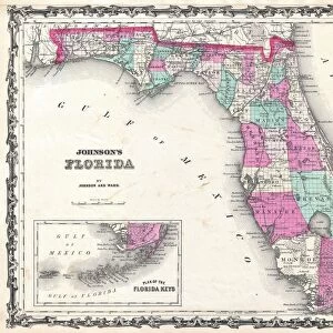
Canvas Print : 1855, Colton Map of Florida, topography, cartography, geography, land, illustration


![]()
Canvas Prints from Liszt Collection
1855, Colton Map of Florida, topography, cartography, geography, land, illustration
1855, Colton Map of Florida
Liszt Collection of nineteenth-century engravings and images to browse and enjoy
Media ID 14007470
© Artokoloro Quint Lox Limited
1855 Antique Map Latitude Longitude Mappa Mundi Old Antique Plan Old Antique View Ols Antique Map Rare Old Maps Topo
20"x16" (51x41cm) Canvas Print
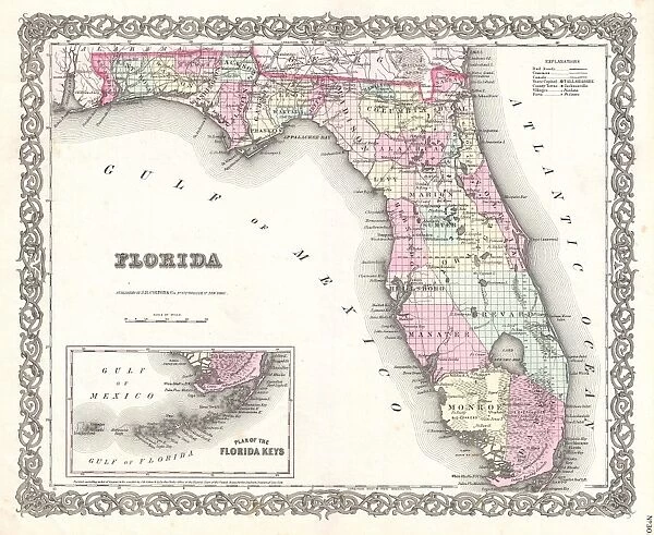
Step into the past with our exquisite Canvas Print from Media Storehouse, featuring the 1855 Colton Map of Florida from the esteemed Liszt Collection. This captivating illustration showcases the intricate cartography and geography of the Sunshine State during that era, with meticulous attention to detail in the topography and land features. Bring the history and beauty of this iconic map into your home or office, and transport yourself back in time. Perfect for history enthusiasts, educators, or anyone who appreciates the art of cartography. Order yours today and let this stunning canvas print tell a story in your space.
Delivered stretched and ready to hang our premium quality canvas prints are made from a polyester/cotton blend canvas and stretched over a 1.25" (32mm) kiln dried knot free wood stretcher bar. Packaged in a plastic bag and secured to a cardboard insert for safe transit.
Canvas Prints add colour, depth and texture to any space. Professionally Stretched Canvas over a hidden Wooden Box Frame and Ready to Hang
Estimated Product Size is 50.8cm x 40.6cm (20" x 16")
These are individually made so all sizes are approximate
Artwork printed orientated as per the preview above, with landscape (horizontal) orientation to match the source image.
EDITORS COMMENTS
This print showcases the intricate details of the 1855 Colton Map of Florida, a true masterpiece in cartography. The topography and geography of this southern state are beautifully illustrated, offering a glimpse into its land formations and natural features. This vintage map, with its ancient charm and historical significance, takes us back to a time when exploration and discovery were at their peak. The carefully crafted lines on this paper relic form an impressive grid system that denotes latitude and longitude coordinates, allowing for precise navigation across Florida's diverse regions. Its geometric precision is reminiscent of mappa mundi maps from centuries ago, adding an extra layer of fascination to this piece. As we delve into the past through this old antique view, we can't help but appreciate the artistry behind it. The decorative elements incorporated into the design make it not only informative but also aesthetically pleasing. It serves as a reminder of how maps were once cherished as valuable artifacts documenting our world's history. With its aged appearance and historic allure, this rare old map transports us to another era—a time when Florida was still being explored and understood by early settlers. Whether you're an avid collector or simply intrigued by historical relics like these, this print offers a unique window into our planet's past that is sure to captivate any viewer.
MADE IN THE USA
Safe Shipping with 30 Day Money Back Guarantee
FREE PERSONALISATION*
We are proud to offer a range of customisation features including Personalised Captions, Color Filters and Picture Zoom Tools
SECURE PAYMENTS
We happily accept a wide range of payment options so you can pay for the things you need in the way that is most convenient for you
* Options may vary by product and licensing agreement. Zoomed Pictures can be adjusted in the Cart.