Canvas Print > Europe > United Kingdom > England > Maps
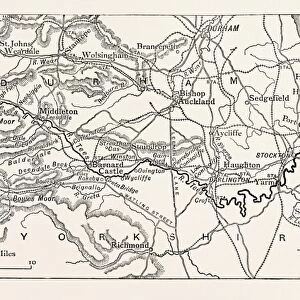
Canvas Print : MAP OF THE COURSE OF THE TEES. The River Tees is in northern England


![]()
Canvas Prints from Liszt Collection
MAP OF THE COURSE OF THE TEES. The River Tees is in northern England
MAP OF THE COURSE OF THE TEES. The River Tees is in northern England. It rises on the eastern slope of Cross Fell in the North Pennines, and flows eastwards for 85 miles (137 km) to reach the North Sea between Hartlepool and Redcar near Middlesbrough. UK
Liszt Collection of nineteenth-century engravings and images to browse and enjoy
Media ID 12830053
© Quint Lox Limited
Course Eastern Flows Miles North Sea Northern Reach Rises River Tees Slope Eastwards Hartlepool Middlesbrough North Pennines Redcar Tees
30"x20" (76x51cm) Canvas Print
"Discover the natural beauty of northern England with our stunning Canvas Print of "Map of the Course of the Tees" from the Liszt Collection. This exquisite piece showcases the winding river Tees as it meanders through the picturesque landscape of the North Pennines. The rich, textured canvas brings out the intricate details of the map, making it a perfect addition to any home or office space. Let this captivating artwork transport you to the serene beauty of the English countryside."
Delivered stretched and ready to hang our premium quality canvas prints are made from a polyester/cotton blend canvas and stretched over a 1.25" (32mm) kiln dried knot free wood stretcher bar. Packaged in a plastic bag and secured to a cardboard insert for safe transit.
Canvas Prints add colour, depth and texture to any space. Professionally Stretched Canvas over a hidden Wooden Box Frame and Ready to Hang
Estimated Product Size is 76.2cm x 50.8cm (30" x 20")
These are individually made so all sizes are approximate
Artwork printed orientated as per the preview above, with landscape (horizontal) orientation to match the source image.
FEATURES IN THESE COLLECTIONS
> Arts
> Landscape paintings
> Waterfall and river artworks
> River artworks
> Europe
> United Kingdom
> England
> Maps
> Europe
> United Kingdom
> England
> Rivers
> Europe
> United Kingdom
> Maps
> Maps and Charts
> Related Images
EDITORS COMMENTS
This vintage print showcases the "Map of the Course of the Tees" a historical representation of the River Tees in northern England. With its intricate engravement and illustrative technique, this nineteenth-century image takes us on a journey through time to explore the natural beauty and rich history of this iconic river. The River Tees originates on the eastern slope of Cross Fell in the North Pennines, gracefully flowing eastwards for an impressive 85 miles (137 km). As we follow its course, we witness how it meanders through picturesque landscapes before finally reaching its destination –the majestic North Sea between Hartlepool and Redcar near Middlesbrough. This vintage print not only captures geographical details but also offers a glimpse into Victorian arts and culture. Its retro-styled design evokes nostalgia while reminding us of the artistic mastery prevalent during that era. The engraving itself is a testament to both technical skill and artistic expression. As we admire this historic piece, let us appreciate how it serves as a window into our past, allowing us to connect with generations gone by. It reminds us of our enduring fascination with nature's wonders and our desire to document them artistically. So take a moment to immerse yourself in this enchanting map that encapsulates both geography and artistry—a true treasure from Arkheia's Liszt Collection.
MADE IN THE USA
Safe Shipping with 30 Day Money Back Guarantee
FREE PERSONALISATION*
We are proud to offer a range of customisation features including Personalised Captions, Color Filters and Picture Zoom Tools
SECURE PAYMENTS
We happily accept a wide range of payment options so you can pay for the things you need in the way that is most convenient for you
* Options may vary by product and licensing agreement. Zoomed Pictures can be adjusted in the Cart.