Canvas Print > Arts > Artists > H > Wenceslaus Hollar
Canvas Print : Map Minden Minda saxoniae inferioris ad Vi title


![]()
Canvas Prints from Liszt Collection
Map Minden Minda saxoniae inferioris ad Vi title
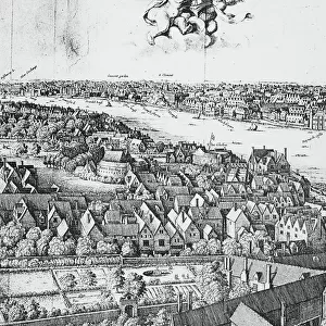
Map of Minden Minda saxoniae inferioris ad Vi (...) (title on object), Map of the city of Minden with buildings in a birds eye view. Top left the title cartouche with text in Latin, below a compass, top right a coat of arms, prospect or city, town panorama, silhouette of city, coat of arms (as symbol of the state, etc.) (province, provincial), fortified city, Minden, Wenceslaus Hollar, Germany, 1657, paper, etching, h 372 mm × w 508 mm
Liszt Collection of nineteenth-century engravings and images to browse and enjoy
Media ID 19545205
© Artokoloro
1657 Arms City Coat Compass Fortified City Latin Prospect Province Provincial Silhouette State Symbol Text Title Top Left Top Right Town Panorama Wenceslaus Hollar Minden
20"x16" (51x41cm) Canvas Print
Discover the historical charm of the past with our exquisite Canvas Prints from the Media Storehouse collection. Feast your eyes on this intricately detailed Map of Minden, Minda saxoniae inferioris ad Vi, hailing from the esteemed Liszt Collection. This captivating bird's eye view map showcases the architectural wonders of the city of Minden in a stunning, vintage style. Transport yourself back in time as the intricate lines and shades bring the map to life on your wall. A perfect addition to any home office, library, or historical decor.
Delivered stretched and ready to hang our premium quality canvas prints are made from a polyester/cotton blend canvas and stretched over a 1.25" (32mm) kiln dried knot free wood stretcher bar. Packaged in a plastic bag and secured to a cardboard insert for safe transit.
Canvas Prints add colour, depth and texture to any space. Professionally Stretched Canvas over a hidden Wooden Box Frame and Ready to Hang
Estimated Product Size is 50.8cm x 40.6cm (20" x 16")
These are individually made so all sizes are approximate
Artwork printed orientated as per the preview above, with landscape (horizontal) orientation to match the source image.
FEATURES IN THESE COLLECTIONS
> Arts
> Artists
> H
> Wenceslaus Hollar
> Maps and Charts
> Related Images
EDITORS COMMENTS
This print showcases a historic map titled "Map Minden Minda saxoniae inferioris ad Vi title". Created by Wenceslaus Hollar in 1657, this etching on paper measures 372 mm in height and 508 mm in width. The map provides a bird's eye view of the city of Minden, Germany, with intricate details of its buildings. In the top left corner, we find a beautifully designed title cartouche adorned with Latin text. Just below it lies a compass, indicating the precision and accuracy employed in creating this masterpiece. On the top right side, an impressive coat of arms proudly represents the state or province to which Minden belongs. The main focus of this artwork is undoubtedly the panoramic silhouette of Minden itself. Every street and structure has been meticulously depicted to provide viewers with an immersive experience into the city's architectural beauty. This fortified city stands as a testament to its historical significance. Wenceslaus Hollar's attention to detail and artistic skill are evident throughout this extraordinary piece. As you explore every inch of this map print, allow yourself to be transported back in time to witness Minden's grandeur during the mid-17th century
MADE IN THE USA
Safe Shipping with 30 Day Money Back Guarantee
FREE PERSONALISATION*
We are proud to offer a range of customisation features including Personalised Captions, Color Filters and Picture Zoom Tools
SECURE PAYMENTS
We happily accept a wide range of payment options so you can pay for the things you need in the way that is most convenient for you
* Options may vary by product and licensing agreement. Zoomed Pictures can be adjusted in the Cart.