Canvas Print > Europe > United Kingdom > Wales > Maps
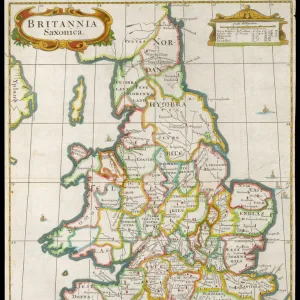
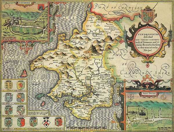
Canvas Print : Pembrokeshire Historical John Speed 1610 Map


![]()
Canvas Prints from Map Marketing
Pembrokeshire Historical John Speed 1610 Map
A reproduction of John Speeds historical map of the county of Pembrokeshire. Originally published as part of his atlas called The Theatre of the Empire of Great Britain in 1610. John Speed ((1552-1629) was a renowned English cartographer, his maps themselves were of high quality and gained a great reputation for being among the best county maps
Media ID 19949687
© Map Marketing Ltd
1610 Historical Map John Speed Pembrokeshire Wales
20"x16" (51x41cm) Canvas Print
Delivered stretched and ready to hang our premium quality canvas prints are made from a polyester/cotton blend canvas and stretched over a 1.25" (32mm) kiln dried knot free wood stretcher bar. Packaged in a plastic bag and secured to a cardboard insert for safe transit.
Canvas Prints add colour, depth and texture to any space. Professionally Stretched Canvas over a hidden Wooden Box Frame and Ready to Hang
Estimated Product Size is 50.8cm x 40.6cm (20" x 16")
These are individually made so all sizes are approximate
Artwork printed orientated as per the preview above, with landscape (horizontal) orientation to match the source image.
FEATURES IN THESE COLLECTIONS
> Arts
> Artists
> S
> John Speed
> Europe
> United Kingdom
> Wales
> Maps
> Europe
> United Kingdom
> Wales
> Pembrokeshire
> Related Images
> Europe
> United Kingdom
> Wales
> Posters
> Europe
> United Kingdom
> Wales
> Related Images
> Maps and Charts
> British Empire Maps
> Maps and Charts
> Early Maps
> Maps and Charts
> Related Images
> Maps and Charts
> Wales
MADE IN THE USA
Safe Shipping with 30 Day Money Back Guarantee
FREE PERSONALISATION*
We are proud to offer a range of customisation features including Personalised Captions, Color Filters and Picture Zoom Tools
SECURE PAYMENTS
We happily accept a wide range of payment options so you can pay for the things you need in the way that is most convenient for you
* Options may vary by product and licensing agreement. Zoomed Pictures can be adjusted in the Cart.