Canvas Print > North America > United States of America > Maps
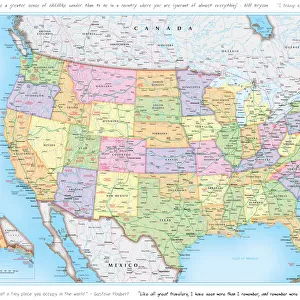
Canvas Print : USA Political Map


![]()
Canvas Prints from Map Marketing
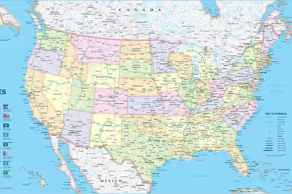
USA Political Map
This very clean and clear USA political map shows each State in a different colour as well as principal cities and towns divided into six separate population bands. It also shows the main road network with Interstate highways highlighted, railways, main airports, State capitals, State and international boundaries are all marked. The USA political map also includes a key panel showing the flag for each US State detailing the State capital, population and geographical size
Media ID 19951695
© Map Marketing Ltd
30"x20" (76x51cm) Canvas Print
Delivered stretched and ready to hang our premium quality canvas prints are made from a polyester/cotton blend canvas and stretched over a 1.25" (32mm) kiln dried knot free wood stretcher bar. Packaged in a plastic bag and secured to a cardboard insert for safe transit.
Canvas Prints add colour, depth and texture to any space. Professionally Stretched Canvas over a hidden Wooden Box Frame and Ready to Hang
Estimated Product Size is 76.2cm x 50.8cm (30" x 20")
These are individually made so all sizes are approximate
Artwork printed orientated as per the preview above, with landscape (horizontal) orientation to match the source image.
FEATURES IN THESE COLLECTIONS
> Maps and Charts
> Related Images
> North America
> United States of America
> Maps
> Popular Themes
> Railway Posters
MADE IN THE USA
Safe Shipping with 30 Day Money Back Guarantee
FREE PERSONALISATION*
We are proud to offer a range of customisation features including Personalised Captions, Color Filters and Picture Zoom Tools
SECURE PAYMENTS
We happily accept a wide range of payment options so you can pay for the things you need in the way that is most convenient for you
* Options may vary by product and licensing agreement. Zoomed Pictures can be adjusted in the Cart.