Canvas Print > Europe > United Kingdom > England > West Midlands > Related Images
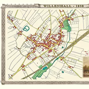
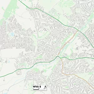
Canvas Print : Old Map of the Town of Willenhall in the West Midlands 1884


![]()
Canvas Prints from MapSeeker
Old Map of the Town of Willenhall in the West Midlands 1884
PL024
Welcome to the Mapseeker Image library and enter an historic gateway to one of the largest on-line collections of Historic Maps, Nostalgic Views, Vista's and Panorama's from a World gone by.
Media ID 20347124
Historic Map Old Town Plan Town Plan
30"x20" (76x51cm) Canvas Print
"Step back in time with our exquisite Canvas Print of an Old Map of Willenhall, West Midlands from 1884. This stunning piece, sourced from MapSeeker, brings history to life with intricate detail and vibrant colors. The Old Map of Willenhall (PL024) is meticulously printed onto high-quality canvas, ensuring a rich, textured finish. Perfect for adding a unique touch to any room, this captivating canvas print is a must-have for history enthusiasts and locals alike. Hang it in your home or office to start a conversation and inspire curiosity."
Delivered stretched and ready to hang our premium quality canvas prints are made from a polyester/cotton blend canvas and stretched over a 1.25" (32mm) kiln dried knot free wood stretcher bar. Packaged in a plastic bag and secured to a cardboard insert for safe transit.
Canvas Prints add colour, depth and texture to any space. Professionally Stretched Canvas over a hidden Wooden Box Frame and Ready to Hang
Estimated Product Size is 76.2cm x 50.8cm (30" x 20")
These are individually made so all sizes are approximate
Artwork printed orientated as per the preview above, with landscape (horizontal) orientation to match the source image.
FEATURES IN THESE COLLECTIONS
> Europe
> United Kingdom
> England
> West Midlands
> Related Images
> MapSeeker
> British Town And City Plans
> English & Welsh PORTFOLIO
EDITORS COMMENTS
This print showcases an exquisite piece of history, the "Old Map of the Town of Willenhall in the West Midlands 1884 (PL024)". Stepping back in time, this remarkable map offers a glimpse into the past, revealing the intricate details and layout of Willenhall during its formative years. With meticulous precision, every street, building, and landmark is meticulously depicted on this vintage treasure. Transporting us to a bygone era, this old map of Willenhall serves as a fascinating window into how the town has evolved over time. It sparks curiosity about what life was like for its residents in 1884 – their daily routines, bustling markets, and vibrant community spirit that once thrived within these streets. The historic significance of this town plan cannot be overstated. It allows us to appreciate how urban planning has shaped our cities throughout centuries. From narrow alleyways to grand boulevards lined with charming Victorian architecture; each element tells a story waiting to be discovered. Whether you are an avid historian or simply captivated by maps' allure, this mesmerizing print will undoubtedly become a cherished addition to your collection. Display it proudly on your wall and let it ignite conversations about local heritage and cultural preservation
MADE IN THE USA
Safe Shipping with 30 Day Money Back Guarantee
FREE PERSONALISATION*
We are proud to offer a range of customisation features including Personalised Captions, Color Filters and Picture Zoom Tools
SECURE PAYMENTS
We happily accept a wide range of payment options so you can pay for the things you need in the way that is most convenient for you
* Options may vary by product and licensing agreement. Zoomed Pictures can be adjusted in the Cart.