Canvas Print > Arts > Artists > T > John Tallis
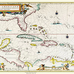
Canvas Print : Old Map of Central America 1851 by John Tallis


![]()
Canvas Prints from MapSeeker
Old Map of Central America 1851 by John Tallis
A fine facimile artworked from an antique original map of Central America, issued as part of the 1851 edition of John Tallis and Companys " The Illustrated Atlas and Modern History of the World"
Welcome to the Mapseeker Image library and enter an historic gateway to one of the largest on-line collections of Historic Maps, Nostalgic Views, Vista's and Panorama's from a World gone by.
Media ID 20347380
© Mapseeker Publishing Ltd
John Tallis John Tallis Map Tallis Map
30"x20" (76x51cm) Canvas Print
Step back in time with our exquisite Canvas Print of the Old Map of Central America, 1851 by John Tallis and John Rapkin from MapSeeker. This beautiful piece is a meticulous facsimile of the antique original map, taken from the esteemed 1851 edition of John Tallis & Co.'s "The Illustrated Atlas." Bring history into your home with this captivating and intricately detailed representation of Central America's geography as it was understood over a century and a half ago. Our Canvas Prints are known for their vibrant colors, rich textures, and museum-quality finish, ensuring that this historic map will be a stunning addition to any room in your home or office.
Delivered stretched and ready to hang our premium quality canvas prints are made from a polyester/cotton blend canvas and stretched over a 1.25" (32mm) kiln dried knot free wood stretcher bar. Packaged in a plastic bag and secured to a cardboard insert for safe transit.
Canvas Prints add colour, depth and texture to any space. Professionally Stretched Canvas over a hidden Wooden Box Frame and Ready to Hang
Estimated Product Size is 76.2cm x 50.8cm (30" x 20")
These are individually made so all sizes are approximate
Artwork printed orientated as per the preview above, with landscape (horizontal) orientation to match the source image.
FEATURES IN THESE COLLECTIONS
> Arts
> Artists
> T
> John Tallis
> Maps and Charts
> Related Images
> Maps and Charts
> World
> MapSeeker
> Maps of the Americas
> Maps of Central and South America
EDITORS COMMENTS
This print showcases the "Old Map of Central America 1851" by John Tallis, a remarkable facsimile artwork derived from an antique original map. Originally published as part of the 1851 edition of John Tallis and Company's renowned "The Illustrated Atlas and Modern History of the World" this map offers a fascinating glimpse into the past. With intricate details and exquisite craftsmanship, this vintage map takes us on a journey through time to explore Central America during the mid-19th century. From Mexico down to Panama, it vividly depicts the various countries that make up this vibrant region. The delicate lines trace coastlines, rivers, and mountain ranges while highlighting major cities and towns along with their historical names. As we gaze upon this piece, we are transported back to an era when cartography was both artistry and science. The meticulous attention to detail in every corner reflects not only Tallis' expertise but also his dedication to capturing geographical accuracy. This print is more than just a decorative item; it serves as a window into history—a testament to exploration and discovery during an age where maps were essential tools for understanding our world. Whether you have an affinity for old maps or simply appreciate fine artistry, this stunning reproduction by John Tallis will undoubtedly captivate your imagination with its rich historical significance.
MADE IN THE USA
Safe Shipping with 30 Day Money Back Guarantee
FREE PERSONALISATION*
We are proud to offer a range of customisation features including Personalised Captions, Color Filters and Picture Zoom Tools
SECURE PAYMENTS
We happily accept a wide range of payment options so you can pay for the things you need in the way that is most convenient for you
* Options may vary by product and licensing agreement. Zoomed Pictures can be adjusted in the Cart.