Canvas Print > Arts > Artists > T > John Tallis
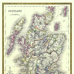
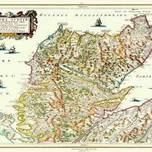
Canvas Print : Scotland 1851


![]()
Canvas Prints from MapSeeker
Scotland 1851
A fine facimile artworked from an antique original map of Scotland, issued as part of the 1851 edition of John Tallis and Companys " The Illustrated Atlas and Modern History of the World"
Welcome to the Mapseeker Image library and enter an historic gateway to one of the largest on-line collections of Historic Maps, Nostalgic Views, Vista's and Panorama's from a World gone by.
Media ID 20347229
© Mapseeker Publishing Ltd
John Tallis John Tallis Map Old Map Of Scotland Old Scotland Map Old Scottish Map Scotland Scotland Map Scottish Map Tallis Map
30"x20" (76x51cm) Canvas Print
Experience the rich history of Scotland with our Media Storehouse Canvas Print of "Scotland 1851" by John Tallis and John Rapkin from MapSeeker. This stunning, museum-quality reproduction is taken from an original antique map published in the 1851 edition of John Tallis and Company's "The Illustrated Atlas and Modern History of the World." Each detail is carefully captured in vibrant colors and high resolution, bringing the intricate cartography and historical details to life. Add a touch of history and character to your home or office with this beautiful and authentic canvas print.
Delivered stretched and ready to hang our premium quality canvas prints are made from a polyester/cotton blend canvas and stretched over a 1.25" (32mm) kiln dried knot free wood stretcher bar. Packaged in a plastic bag and secured to a cardboard insert for safe transit.
Canvas Prints add colour, depth and texture to any space. Professionally Stretched Canvas over a hidden Wooden Box Frame and Ready to Hang
Estimated Product Size is 50.8cm x 76.2cm (20" x 30")
These are individually made so all sizes are approximate
Artwork printed orientated as per the preview above, with portrait (vertical) orientation to match the source image.
FEATURES IN THESE COLLECTIONS
> Arts
> Artists
> T
> John Tallis
> Europe
> United Kingdom
> Scotland
> Maps
> Maps and Charts
> Related Images
> Maps and Charts
> World
> MapSeeker
> Maps from the British Isles
> Scotland and Counties PORTFOLIO
EDITORS COMMENTS
This print showcases a remarkable piece of history - a fine facsimile artworked from an antique original map of Scotland dating back to 1851. The map was originally issued as part of the renowned 1851 edition of John Tallis and Company's "The Illustrated Atlas and Modern History of the World". With intricate details and exquisite craftsmanship, this old map offers a glimpse into Scotland's past, capturing its geographical features, towns, cities, and landmarks with precision. Every stroke on this historic cartographic masterpiece tells a story about the country's rich heritage. John Tallis, along with his talented collaborator John Rapkin, meticulously crafted this Scottish map to provide not only geographical information but also cultural insights. As one explores this vintage treasure trove, they can immerse themselves in the world as it existed over 150 years ago. Transporting us back in time, this print allows us to appreciate the artistry involved in creating such maps during an era when cartography was both science and art. It serves as a reminder that maps are not merely tools for navigation but windows into our collective past. Whether you have ancestral ties to Scotland or simply admire historical artifacts, this old Scottish map is sure to captivate your imagination and spark conversations about bygone eras.
MADE IN THE USA
Safe Shipping with 30 Day Money Back Guarantee
FREE PERSONALISATION*
We are proud to offer a range of customisation features including Personalised Captions, Color Filters and Picture Zoom Tools
SECURE PAYMENTS
We happily accept a wide range of payment options so you can pay for the things you need in the way that is most convenient for you
* Options may vary by product and licensing agreement. Zoomed Pictures can be adjusted in the Cart.