Canvas Print > Arts > Portraits > Pop art gallery > Street art portraits
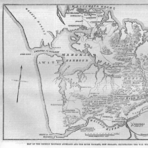
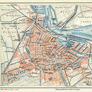
Canvas Print : Amsterdam Plan


![]()
Canvas Prints from Mary Evans Picture Library
Amsterdam Plan
A pre-railway plan showing how the streets and canals have been built concentrically round the city centre. Date: mid-19th century
Mary Evans Picture Library makes available wonderful images created for people to enjoy over the centuries
Media ID 586882
© Mary Evans Picture Library 2015 - https://copyrighthub.org/s0/hub1/creation/maryevans/MaryEvansPictureID/10180195
20"x16" (51x41cm) Canvas Print
Discover the timeless charm of the past with our exquisite Amsterdam Plan Canvas Print from Media Storehouse, featuring an intriguing pre-railway design by Mary Evans Picture Library. This captivating mid-19th century map showcases the concentrically built streets and canals that surround the city centre of Amsterdam, offering a fascinating glimpse into its rich history. Add an element of old-world elegance to your home or office décor with this beautifully detailed and vibrant print. Each canvas is meticulously printed with archival quality inks and coated with a protective varnish, ensuring long-lasting vibrancy and durability. Experience the allure of Amsterdam's history like never before with this stunning canvas print from Media Storehouse.
Delivered stretched and ready to hang our premium quality canvas prints are made from a polyester/cotton blend canvas and stretched over a 1.25" (32mm) kiln dried knot free wood stretcher bar. Packaged in a plastic bag and secured to a cardboard insert for safe transit.
Canvas Prints add colour, depth and texture to any space. Professionally Stretched Canvas over a hidden Wooden Box Frame and Ready to Hang
Estimated Product Size is 50.8cm x 40.6cm (20" x 16")
These are individually made so all sizes are approximate
Artwork printed orientated as per the preview above, with landscape (horizontal) orientation to match the source image.
FEATURES IN THESE COLLECTIONS
> Arts
> Portraits
> Pop art gallery
> Street art portraits
> Popular Themes
> Railway Posters
EDITORS COMMENTS
This fascinating print showcases the mid-19th century Amsterdam Plan, revealing how the streets and canals were meticulously built concentrically around the city center. The intricate design of this historical map provides a glimpse into the urban development of Amsterdam before the introduction of railways.
The detailed layout highlights the strategic planning that went into creating a functional and aesthetically pleasing cityscape. Each street and canal is carefully mapped out, demonstrating a harmonious balance between form and function. It's clear that every aspect of this plan was thoughtfully considered to optimize transportation, commerce, and overall livability within Amsterdam.
As we study this pre-railway plan, we are transported back in time to an era when urban planning was both an art and a science. The concentric arrangement of streets and canals reflects a deep understanding of spatial organization and efficiency. It's truly remarkable to see how cities like Amsterdam were able to thrive even without modern transportation systems.
This print from Mary Evans Picture Library serves as a valuable historical document, shedding light on the evolution of urban landscapes in Europe. It's a reminder of the rich history behind our modern cities and how thoughtful planning has shaped their development over centuries.
MADE IN THE USA
Safe Shipping with 30 Day Money Back Guarantee
FREE PERSONALISATION*
We are proud to offer a range of customisation features including Personalised Captions, Color Filters and Picture Zoom Tools
SECURE PAYMENTS
We happily accept a wide range of payment options so you can pay for the things you need in the way that is most convenient for you
* Options may vary by product and licensing agreement. Zoomed Pictures can be adjusted in the Cart.