Canvas Print > Europe > Spain > Maps
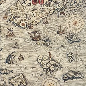
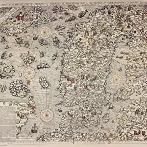
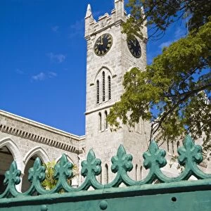
Canvas Print : Carta marina (map of the sea). 1516. Facsimile
. 1516. Facsimile")

. 1516. Facsimile")


![]()
Canvas Prints from Mary Evans Picture Library
Carta marina (map of the sea). 1516. Facsimile
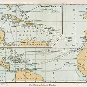
" Carta marina (map of the sea). 1516. Facsimile. Sea map described by Carlos Sainz in his work " The name of America". Engraving. SPAIN. Madrid. Americas Museum."
Mary Evans Picture Library makes available wonderful images created for people to enjoy over the centuries
Media ID 8282597
© Mary Evans Picture Library 2015 - https://copyrighthub.org/s0/hub1/creation/maryevans/MaryEvansPictureID/10682012
Carlos Carta Cartography Chart Cities Compass Engravings Facsimile Marina Nautical
30"x20" (76x51cm) Canvas Print
Introducing the captivating Canvas Print from Media Storehouse, featuring the intriguing "Carta marina (map of the sea). 1516. Facsimile" by Rights Managed from Mary Evans Prints Online. This historic sea map, described by Carlos Sainz in his work "The name of America," is a fascinating glimpse into the past. Originally engraved in Spain, Madrid, at the Americas Museum, this reproduction brings the rich history of cartography to life in your home or office. With vibrant colors and crisp details, this canvas print is not only an exquisite piece of art but also a conversation starter. Elevate your space with this captivating and educational addition.
Delivered stretched and ready to hang our premium quality canvas prints are made from a polyester/cotton blend canvas and stretched over a 1.25" (32mm) kiln dried knot free wood stretcher bar. Packaged in a plastic bag and secured to a cardboard insert for safe transit.
Canvas Prints add colour, depth and texture to any space. Professionally Stretched Canvas over a hidden Wooden Box Frame and Ready to Hang
Estimated Product Size is 76.2cm x 50.8cm (30" x 20")
These are individually made so all sizes are approximate
Artwork printed orientated as per the preview above, with landscape (horizontal) orientation to match the source image.
FEATURES IN THESE COLLECTIONS
> Europe
> Spain
> Related Images
> Maps and Charts
> Related Images
> Maps and Charts
> Spain
EDITORS COMMENTS
This facsimile print showcases the historic Carta marina, or Sea Map, created in 1516. The intricately detailed engraving is described in Carlos Sainz's renowned work, "The Name of America." Housed in the esteemed Americas Museum in Madrid, Spain, this precious artifact offers a glimpse into the rich history of cartography and nautical exploration during the 16th century. The Carta marina is a seminal work in the history of cartography, as it is one of the earliest maps to depict the Americas accurately, featuring the eastern coastline of South America and the Caribbean islands. The map's creator remains unknown, but it is believed to have been produced in Spain, likely for the use of the Spanish Crown and its expanding maritime empire. The map's intricate details include the depiction of various cities, bays, and islands, as well as the inclusion of a compass rose and other navigational aids. The engraving process, which involved carving the design into a copper plate and then printing it onto paper, allowed for the production of multiple copies with remarkable precision. This facsimile print invites us to explore the fascinating world of early cartography and the intrepid explorers who braved the unknown waters of the Atlantic Ocean. It serves as a testament to the power of human curiosity and the enduring allure of the sea.
MADE IN THE USA
Safe Shipping with 30 Day Money Back Guarantee
FREE PERSONALISATION*
We are proud to offer a range of customisation features including Personalised Captions, Color Filters and Picture Zoom Tools
SECURE PAYMENTS
We happily accept a wide range of payment options so you can pay for the things you need in the way that is most convenient for you
* Options may vary by product and licensing agreement. Zoomed Pictures can be adjusted in the Cart.