Canvas Print > Europe > Croatia > Maps
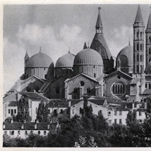
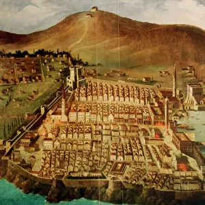
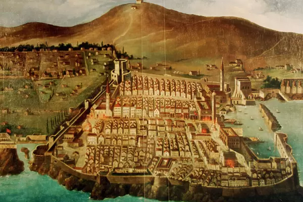
Canvas Print : Dubrovnik. Map of the city before the earthquake of 1667


![]()
Canvas Prints from Mary Evans Picture Library
Dubrovnik. Map of the city before the earthquake of 1667
Dubrovnik. Map of the city before the earthquake of 1667. Croatia
Mary Evans Picture Library makes available wonderful images created for people to enjoy over the centuries
Media ID 14340468
© Thaliastock / Mary Evans
Adriatic Cartography Contour Croatia Croatian Dalmatian Dubrovnik Mapping Pearl Perimeter Seventeenth Walled Xvii Xviith
30"x20" (76x51cm) Canvas Print
Discover the rich history of Dubrovnik with our stunning Canvas Print of "Dubrovnik. Map of the city before the earthquake of 1667" from Media Storehouse. This captivating piece, sourced from Mary Evans Prints Online, offers a unique glimpse into the past with an intricately detailed map of the Croatian city before the devastating earthquake of 1667. Bring the history and culture of Dubrovnik into your home or office with this beautiful and thought-provoking work of art. Our high-quality Canvas Prints are made to last, with vibrant colors and sharp details that truly bring the image to life. Order yours today and step back in time.
Delivered stretched and ready to hang our premium quality canvas prints are made from a polyester/cotton blend canvas and stretched over a 1.25" (32mm) kiln dried knot free wood stretcher bar. Packaged in a plastic bag and secured to a cardboard insert for safe transit.
Canvas Prints add colour, depth and texture to any space. Professionally Stretched Canvas over a hidden Wooden Box Frame and Ready to Hang
Estimated Product Size is 76.2cm x 50.8cm (30" x 20")
These are individually made so all sizes are approximate
Artwork printed orientated as per the preview above, with landscape (horizontal) orientation to match the source image.
FEATURES IN THESE COLLECTIONS
> Europe
> Croatia
> Related Images
> Maps and Charts
> Early Maps
> Maps and Charts
> Related Images
EDITORS COMMENTS
This print showcases a historic map of Dubrovnik before the devastating earthquake of 1667. The intricate details and precision of the cartography highlight the city's layout along the stunning Adriatic coast. This 17th-century map provides a glimpse into Dubrovnik's past, showcasing its walled perimeter, mountainous backdrop, and strategic location as a Dalmatian pearl.
The map serves as a window into history, offering insight into Dubrovnik's rich cultural heritage and architectural significance. The careful contouring of the city walls and streets reflects the meticulous craftsmanship of early modern mapping techniques.
Dubrovnik, often referred to as the "Pearl of the Adriatic," has long been admired for its beauty and resilience in the face of natural disasters such as earthquakes. This image captures a moment frozen in time before tragedy struck, preserving the city's historical footprint for future generations to appreciate.
As we gaze upon this piece of Croatian history, we are reminded of Dubrovnik's enduring spirit and timeless allure. It stands as a testament to human ingenuity and perseverance in the face of adversity, making it not just a map but a symbol of strength and resilience.
MADE IN THE USA
Safe Shipping with 30 Day Money Back Guarantee
FREE PERSONALISATION*
We are proud to offer a range of customisation features including Personalised Captions, Color Filters and Picture Zoom Tools
SECURE PAYMENTS
We happily accept a wide range of payment options so you can pay for the things you need in the way that is most convenient for you
* Options may vary by product and licensing agreement. Zoomed Pictures can be adjusted in the Cart.