Canvas Print : Map of Western Ocean


![]()
Canvas Prints from Mary Evans Picture Library
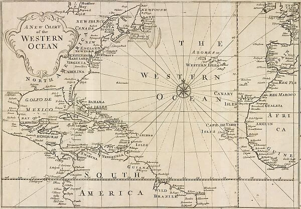
Map of Western Ocean
Map of the Western Ocean taken from Voyage to Jamaica (1707-25) by Sir Hans Sloane (1660-1753)
Mary Evans Picture Library makes available wonderful images created for people to enjoy over the centuries
Media ID 8581363
© Mary Evans Picture Library 2015 - https://copyrighthub.org/s0/hub1/creation/maryevans/MaryEvansPictureID/10710037
Caribbean Chart Exploration Explorer Greater Antilles Jamaica Sir Hans Sloane Sloane Voyage
20"x16" (51x41cm) Canvas Print
"Discover the rich history of exploration with our stunning Canvas Prints from Media Storehouse. Featuring the captivating "Map of the Western Ocean" by Sir Hans Sloane, this exquisite print is sourced from Mary Evans Prints Online. Dating back to the early 18th century, this map offers a fascinating glimpse into the voyages and discoveries of the time. Each Canvas Print is meticulously crafted with high-quality materials, ensuring vibrant colors and sharp details that bring history to life in your home or office. Add a touch of history and adventure to your space with this beautiful and intriguing piece."
Delivered stretched and ready to hang our premium quality canvas prints are made from a polyester/cotton blend canvas and stretched over a 1.25" (32mm) kiln dried knot free wood stretcher bar. Packaged in a plastic bag and secured to a cardboard insert for safe transit.
Canvas Prints add colour, depth and texture to any space. Professionally Stretched Canvas over a hidden Wooden Box Frame and Ready to Hang
Estimated Product Size is 50.8cm x 40.6cm (20" x 16")
These are individually made so all sizes are approximate
Artwork printed orientated as per the preview above, with landscape (horizontal) orientation to match the source image.
EDITORS COMMENTS
This map print, titled "Map of the Western Ocean," offers a glimpse into the intriguing world of 18th-century exploration and discovery. Drawn from the meticulous observations and records of renowned explorer Sir Hans Sloane during his voyage to Jamaica between 1707 and 1725, this map provides a detailed and accurate representation of the Western Ocean, Caribbean Sea, and the Greater Antilles during that era. Sir Hans Sloane, an Irish physician, naturalist, and collector, embarked on his journey to Jamaica at the behest of King James I. His primary objective was to study the natural history of the island, but his voyages also took him to other parts of the Caribbean, allowing him to document the geography of the region with remarkable precision. The map showcases various islands of the Greater Antilles, including Cuba, Jamaica, Hispaniola, and Puerto Rico, as well as the Bahamas and the coastlines of Central America. The intricate detailing of the map reveals the depth contours, underwater features, and even the locations of known shipwrecks. The "Map of the Western Ocean" is an essential historical document that sheds light on the early European exploration of the Caribbean and the Americas. Sir Hans Sloane's contributions to cartography and natural history laid the groundwork for future explorers and scientists, expanding the collective knowledge of the world during the Age of Discovery. This map print is a testament to the spirit of adventure and curiosity that fueled the exploration of new lands and waters, and it continues to captivate and inspire us today as a reminder of the rich history of discovery and the wonders of the natural world.
MADE IN THE USA
Safe Shipping with 30 Day Money Back Guarantee
FREE PERSONALISATION*
We are proud to offer a range of customisation features including Personalised Captions, Color Filters and Picture Zoom Tools
SECURE PAYMENTS
We happily accept a wide range of payment options so you can pay for the things you need in the way that is most convenient for you
* Options may vary by product and licensing agreement. Zoomed Pictures can be adjusted in the Cart.