Canvas Print > Europe > Republic of Ireland > Maps
Canvas Print : MAPS / BRITAIN / 1763


![]()
Canvas Prints from Mary Evans Picture Library
MAPS / BRITAIN / 1763
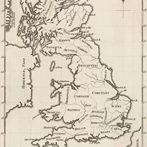
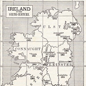
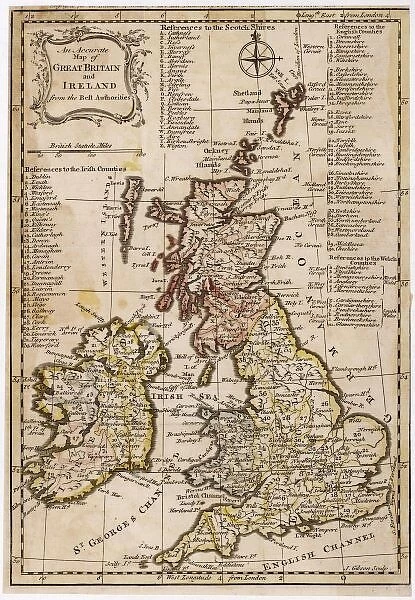
An accurate map of Great Britain and Ireland from the best authorities
Mary Evans Picture Library makes available wonderful images created for people to enjoy over the centuries
Media ID 620765
© Mary Evans Picture Library 2015 - https://copyrighthub.org/s0/hub1/creation/maryevans/MaryEvansPictureID/10074331
1763 Accurate Authorities Best Maps
30"x20" (76x51cm) Canvas Print
Discover the rich history of Britain with our exquisite Canvas Prints from the Media Storehouse collection, featuring the captivating map "MAPS / BRITAIN / 1763" by Mary Evans Picture Library. This detailed and accurate representation of Great Britain and Ireland, sourced from Mary Evans Prints Online, transports you back in time to 1763. Each print is meticulously reproduced onto high-quality canvas, ensuring vibrant colors and stunning detail that bring the intricacies of the map to life. Elevate your home or office décor with this beautiful piece of historical art.
Delivered stretched and ready to hang our premium quality canvas prints are made from a polyester/cotton blend canvas and stretched over a 1.25" (32mm) kiln dried knot free wood stretcher bar. Packaged in a plastic bag and secured to a cardboard insert for safe transit.
Canvas Prints add colour, depth and texture to any space. Professionally Stretched Canvas over a hidden Wooden Box Frame and Ready to Hang
Estimated Product Size is 50.8cm x 76.2cm (20" x 30")
These are individually made so all sizes are approximate
Artwork printed orientated as per the preview above, with portrait (vertical) orientation to match the source image.
FEATURES IN THESE COLLECTIONS
> Europe
> Republic of Ireland
> Maps
> Maps and Charts
> Early Maps
> Maps and Charts
> Related Images
EDITORS COMMENTS
This stunning print captures a piece of history with an accurate map of Great Britain and Ireland from 1763. Created by the best authorities of the time, this detailed map provides a glimpse into the geographical landscape of Britain and Ireland during this significant period in history.
The intricate details on the map showcase the various regions, cities, and landmarks that were present over two centuries ago. From London to Dublin, Edinburgh to Cardiff, each location is meticulously labeled, giving viewers a sense of how these countries were structured in the past.
As we study this historical map, we can appreciate the craftsmanship and expertise that went into creating such an accurate representation of Great Britain and Ireland. It serves as a reminder of how far cartography has come since then while also highlighting the importance of preserving these pieces of our past.
Whether you're a history buff or simply fascinated by maps, this print from Mary Evans Picture Library is sure to captivate your imagination. Step back in time and explore Great Britain and Ireland as it was seen through the eyes of experts in 1763 - a true treasure for any lover of historical artifacts.
MADE IN THE USA
Safe Shipping with 30 Day Money Back Guarantee
FREE PERSONALISATION*
We are proud to offer a range of customisation features including Personalised Captions, Color Filters and Picture Zoom Tools
SECURE PAYMENTS
We happily accept a wide range of payment options so you can pay for the things you need in the way that is most convenient for you
* Options may vary by product and licensing agreement. Zoomed Pictures can be adjusted in the Cart.