Canvas Print > Maps and Charts > British Empire Maps
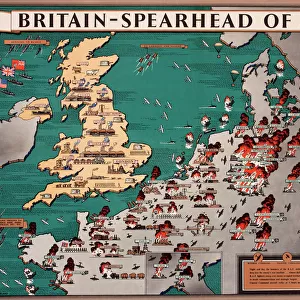
Canvas Print : Empire map of the world


![]()
Canvas Prints from Mary Evans Picture Library
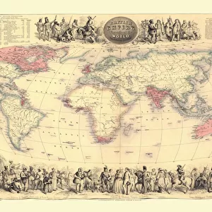
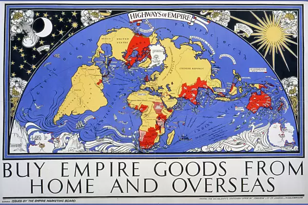
Empire map of the world
Mary Evans Picture Library makes available wonderful images created for people to enjoy over the centuries
Media ID 7401367
© Mary Evans Picture Library 2015 - https://copyrighthub.org/s0/hub1/creation/maryevans/MaryEvansPictureID/10473914
30"x20" (76x51cm) Canvas Print
"Experience the grandeur of history with our Empire Map of the World Canvas Print from Media Storehouse. This stunning, high-quality canvas print showcases an intricately detailed map depicting the extent of various empires throughout history, as sourced from Mary Evans Prints Online. Each line and border is crisp and clear, bringing the past to life in your home or office. The rich, vibrant colors and superior print quality are sure to impress, making this an exceptional addition to any space. Order your Empire Map of the World Canvas Print today and embark on a journey through time."
Delivered stretched and ready to hang our premium quality canvas prints are made from a polyester/cotton blend canvas and stretched over a 1.25" (32mm) kiln dried knot free wood stretcher bar. Packaged in a plastic bag and secured to a cardboard insert for safe transit.
Canvas Prints add colour, depth and texture to any space. Professionally Stretched Canvas over a hidden Wooden Box Frame and Ready to Hang
Estimated Product Size is 76.2cm x 50.8cm (30" x 20")
These are individually made so all sizes are approximate
Artwork printed orientated as per the preview above, with landscape (horizontal) orientation to match the source image.
FEATURES IN THESE COLLECTIONS
> Maps and Charts
> British Empire Maps
> Maps and Charts
> Related Images
> Maps and Charts
> World
> Mary Evans Prints Online
> National Archives
EDITORS COMMENTS
Step back in time and explore the vast expanse of the British Empire in this and intricately detailed map print from the 1930s. This Empire map of the world, a stunning example of cartographic art from the interwar period, showcases the reach and influence of the British Empire at the height of its power. The map, with its rich, earthy tones and bold, clear lines, transports us back to an era of imperial grandeur and exploration. The intricate detailing of the map reveals the vast territories under British rule, from the far-flung colonies in the Caribbean and the Pacific to the dominions in Canada, Australia, and New Zealand. The map also highlights the strategic military bases and key ports of the British Empire, providing a glimpse into the naval and military might of the time. The map's design is both functional and aesthetically pleasing, making it an excellent addition to any home or office. This map is a testament to the historical significance of the British Empire during the 1920s and 1930s, a time of great political, economic, and cultural change. It offers a unique perspective on the world as it was then, and serves as a reminder of the rich and complex history that shapes our world today. Printed on high-quality paper, this map print is a must-have for history buffs, cartography enthusiasts, and anyone interested in the history of the British Empire. Hang it on your wall and let it inspire your imagination as you explore the stories and adventures that lie within its borders.
MADE IN THE USA
Safe Shipping with 30 Day Money Back Guarantee
FREE PERSONALISATION*
We are proud to offer a range of customisation features including Personalised Captions, Color Filters and Picture Zoom Tools
SECURE PAYMENTS
We happily accept a wide range of payment options so you can pay for the things you need in the way that is most convenient for you
* Options may vary by product and licensing agreement. Zoomed Pictures can be adjusted in the Cart.