Canvas Print > Animals > Mammals > Cricetidae > Large Deer Mouse
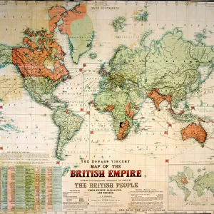
Canvas Print : British Empire world map, 19th century


![]()
Canvas Prints from Science Photo Library
British Empire world map, 19th century
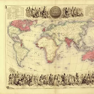
British Empire world map. This world map shows the 19th-century British Empire (pink) and its indigenous peoples. Five illustrations (clockwise from upper left) show the people of Australia, North America, southern Africa, Europe and Asia. Two tables (top left and top right) list the imperial possessions by area and population, with the totals being over 7 million square miles and nearly 165 million people. Some years of acquisition are also shown. This map was produced in the late 1850s by the Scottish cartographer John Bartholomew (1831-1893). Africa includes the 1856 route taken by the Scottish explorer David Livingstone
Science Photo Library features Science and Medical images including photos and illustrations
Media ID 6344993
© LIBRARY OF CONGRESS/SCIENCE PHOTO LIBRARY
1850s Aboriginal Aborigine Africa African Australia Australian British Empire Canada Canadian Cartographic Cartography Deer Empire Exploration Explorer Horses Imperial India Indian Indigenous People Large New Zealand North American Population Scottish Size South Africa South African South America Statistics Territories Victorian World Map Aborigines David Livingstone John Bartholomew Peoples Possessions
20"x16" (51x41cm) Canvas Print
Introducing the captivating and intriguing range of Canvas Prints from Media Storehouse. This stunning collection features an iconic 19th-century British Empire world map from Science Photo Library. This beautifully detailed map showcases the extent of the British Empire at its height, depicted in pink, alongside illustrations of indigenous peoples from Australia, adding a rich historical context to this captivating piece. Bring history into your home or office with this impressive Canvas Print, a perfect conversation starter and a beautiful addition to any room. Order yours today and relive the stories of the past.
Delivered stretched and ready to hang our premium quality canvas prints are made from a polyester/cotton blend canvas and stretched over a 1.25" (32mm) kiln dried knot free wood stretcher bar. Packaged in a plastic bag and secured to a cardboard insert for safe transit.
Canvas Prints add colour, depth and texture to any space. Professionally Stretched Canvas over a hidden Wooden Box Frame and Ready to Hang
Estimated Image Size (if not cropped) is 48.7cm x 40.6cm (19.2" x 16")
Estimated Product Size is 50.8cm x 40.6cm (20" x 16")
These are individually made so all sizes are approximate
Artwork printed orientated as per the preview above, with landscape (horizontal) orientation to match the source image.
FEATURES IN THESE COLLECTIONS
> Africa
> Related Images
> Africa
> South Africa
> Maps
> Africa
> South Africa
> Related Images
> Animals
> Mammals
> Cricetidae
> Large Deer Mouse
> Arts
> Artists
> L
> David Livingstone
> Asia
> India
> Related Images
> Asia
> Related Images
> Europe
> France
> Canton
> Landes
> Europe
> United Kingdom
> England
> Maps
EDITORS COMMENTS
This print showcases a 19th-century British Empire world map, offering a glimpse into the vastness and influence of the empire during that era. The distinctive pink shade represents the territories under British rule, while five intricate illustrations depict the indigenous peoples from different regions across the globe. From Australia to North America, southern Africa to Europe and Asia, these illustrations beautifully capture the diversity of cultures within the empire. Accompanying tables provide fascinating statistics on both land area and population, revealing that this expansive empire covered over 7 million square miles and governed nearly 165 million people. The map also highlights significant years of acquisition, shedding light on key moments in history when new territories were added to Britain's dominion. Created by Scottish cartographer John Bartholomew in the late 1850s, this masterpiece of cartography is not only an artistic representation but also a valuable historical artifact. Notably, it includes David Livingstone's route through Africa in 1856 – a testament to Scotland's contribution to exploration during this time. As we delve into this image, we are transported back to an age where imperial powers shaped global landscapes. It serves as a reminder of Britain's extensive reach and its impact on diverse societies around the world. This remarkable artwork invites us to reflect upon our shared human history and appreciate both cultural differences and commonalities across continents.
MADE IN THE USA
Safe Shipping with 30 Day Money Back Guarantee
FREE PERSONALISATION*
We are proud to offer a range of customisation features including Personalised Captions, Color Filters and Picture Zoom Tools
SECURE PAYMENTS
We happily accept a wide range of payment options so you can pay for the things you need in the way that is most convenient for you
* Options may vary by product and licensing agreement. Zoomed Pictures can be adjusted in the Cart.