Canvas Print > Sheffield City Archives > Maps and Plans > Maps of Sheffield
Canvas Print : Plan of several estates in the townships of Ecclesall Bierlow and Nether Hallam


![]()
Canvas Prints from Sheffield City Archives
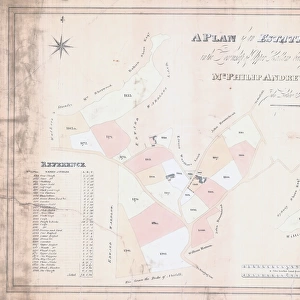
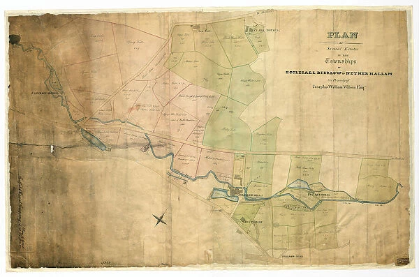
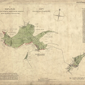
Plan of several estates in the townships of Ecclesall Bierlow and Nether Hallam
Full title: Plan of several estates in the townships of Ecclesall Bierlow and Nether Hallam, the property of Joseph and William Wilson.
Dated [c. 1825-1830]
Porter Brook, Long Field, Square Field, Spring Field, Brocco Bank Allotment, Upper Field, House Field, Tom Field [House], Clark House [sic] Field, Endcliff [sic] Wheel, pingle, Brocco Bank Close, Nether Field, Middle Field, Lower Delf Field, Upper Delph Field, Little Tom Field and part of Nether Field, Wheat Close, Wood Rough and part of Hilly Field, Great Tom Field and part of Halls Meadow, [River Porter], toll bar [Hunters Bar, Endcliffe Park, Ecclesall Road, Brocco Bank, Sharrow Vale], Upper Walsh Stubbing, Lower Walsh Stubbing, Halls Meadow, Lower part of the Meadow, Holme and Meadow, Bagshaw Field, Hilly Field, Meadow Spot, Sharrow Mill, dam and banks, West Brook, Stalker Wheel, Bank Close, House Close, House Field, North Shaw Field, Middle Stalker Lees, Upper South Shaw Field, Lower South Shaw Field, Lower Shaw Field, Breiry Holme, West Shaw Field, East Shaw Field, Upper Shaw Field.
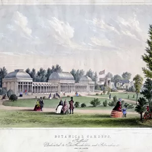
[Covers the following area: Snuff Mill Lane, Stalker Lees Road, General Cemetery, Rosedale Road, Cemetery Avenue, Harefield Road, Denham Road, Harland Road, Neill Road, Eastwood Road. Meadow Terrace, Clarkehouse Road, Botanical Gardens, Endcliffe Vale Road, Botanical Road, Rossington Road, Wiseton Road, Newington Road, Endliffe Terrace Road, Endcliffe Rise Road, Wilson Road, Dover Road, Wadbrough Road, Southgrove Road, Broomgrove Road, Collegiate Crescent, Thompson Road, Khartoum Road, Walton Road, Bristol Road, Bagshot Street, Bruce Road, Westbrook Bank, Stewart Road, Ratcliffe Road, Jarrow Road, Gordon Road, Lynton Road, Wayland Road, Bowood Road].
Original at Sheffield Libraries: arc03951
Sheffield City Archives and Local Studies Library has an unrivalled collection of images of Sheffield, England
Media ID 20503347
© Sheffield City Council - All Rights Reserved
Archives Ecclesall Maps Sheffield Yorkshire
30"x20" (76x51cm) Canvas Print
Step back in time with our exquisite Canvas Print of a historic plan from Sheffield City Archives. This captivating image, titled "Plan of several estates in the townships of Ecclesall Bierlow and Nether Hallam," showcases the property of Joseph and William Wilson. Dated [c], this detailed map offers a fascinating glimpse into the past, perfect for history enthusiasts and local enthusiasts. Our high-quality Canvas Prints bring out the rich colors and intricate details of this rare and beautiful document, making it a stunning addition to any home or office decor. Order yours today and let this piece tell a story of Sheffield's history in your space.
Delivered stretched and ready to hang our premium quality canvas prints are made from a polyester/cotton blend canvas and stretched over a 1.25" (32mm) kiln dried knot free wood stretcher bar. Packaged in a plastic bag and secured to a cardboard insert for safe transit.
Canvas Prints add colour, depth and texture to any space. Professionally Stretched Canvas over a hidden Wooden Box Frame and Ready to Hang
Estimated Product Size is 76.2cm x 50.8cm (30" x 20")
These are individually made so all sizes are approximate
Artwork printed orientated as per the preview above, with landscape (horizontal) orientation to match the source image.
EDITORS COMMENTS
This print showcases the detailed "Plan of several estates in the townships of Ecclesall Bierlow and Nether Hallam" which belonged to Joseph and William Wilson. Dating back to approximately 1825-1830, this historical document provides a fascinating glimpse into the past. The plan encompasses an extensive range of areas, including Porter Brook, Long Field, Square Field, Spring Field, Brocco Bank Allotment, Upper Field, House Field, Tom Field [House], Clark House [sic] Field, Endcliff [sic] Wheel, pingle, Brocco Bank Close, Nether Field, Middle Field, Lower Delf Field. It also covers significant landmarks such as Halls Meadow and Sharrow Mill. Stretching across Snuff Mill Lane to Bowood Road and beyond in Sheffield's vibrant landscape; it encapsulates key locations like Hunters Bar toll bar and Ecclesall Road. The plan even extends its reach towards notable sites like Botanical Gardens and Collegiate Crescent. Preserved at Sheffield Libraries: arc03951 from the Sheffield City Archives collection (not affiliated with any company), this print offers a valuable resource for historians and enthusiasts alike.
MADE IN THE USA
Safe Shipping with 30 Day Money Back Guarantee
FREE PERSONALISATION*
We are proud to offer a range of customisation features including Personalised Captions, Color Filters and Picture Zoom Tools
SECURE PAYMENTS
We happily accept a wide range of payment options so you can pay for the things you need in the way that is most convenient for you
* Options may vary by product and licensing agreement. Zoomed Pictures can be adjusted in the Cart.
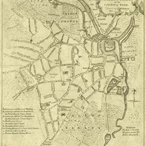
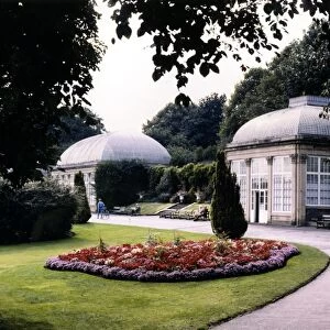
![Plan of an enlargement of the [General] Cemetery and of a new road leading thereto, in the township of Ecclesall Bierlow within the parish of Sheffield, 1846](/sq/716/plan-enlargement-general-cemetery-new-road-14046488.jpg.webp)