Canvas Print > Universal Images Group (UIG) > History
Canvas Print : Fra Mauro map (1460). The Fra Mauro Map orientation (South at the top). is considered
. The Fra Mauro Map orientation (South at the top). is considered")
. The Fra Mauro Map orientation (South at the top). is considered")

![]()
Canvas Prints from Universal Images Group (UIG)
Fra Mauro map (1460). The Fra Mauro Map orientation (South at the top). is considered
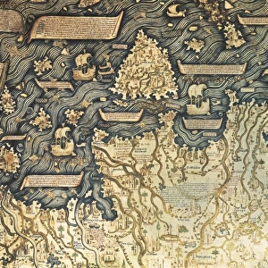
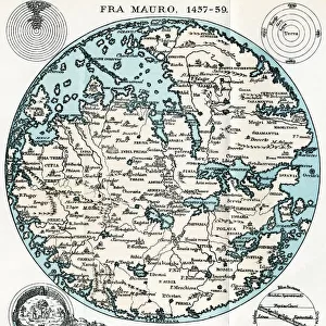
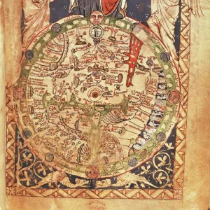
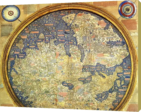
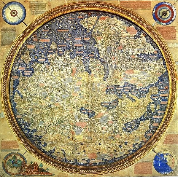
Fra Mauro map (1460). The Fra Mauro Map orientation (South at the top).is considered the greatest memorial of medieval cartography. by the Venetian monk Fra Mauro. It is a circular planisphere drawn on parchment and set in a wooden frame, about two meters in diameter
Universal Images Group (UIG) manages distribution for many leading specialist agencies worldwide
Media ID 9761279
© Universal History Archive/Universal Images Group
Circular Considered Diameter Drawn Frame Greatest Medieval Memorial Monk Parchment Planisphere South Venetian Wooden 1460 Mauro Meters Orientation
20"x16" (51x41cm) Canvas Print
Introducing the Media Storehouse Canvas Prints featuring the renowned Fra Mauro Map (1460). This exquisite cartographic masterpiece, created by the Venetian monk Fra Mauro, is considered the greatest memorial of medieval cartography. Our high-quality Canvas Prints bring the intricate details and authenticity of this historical map to your home or office. The unique orientation of the map, with South at the top, adds an intriguing element to this captivating piece of art and history. Elevate your space with the rich heritage and beauty of this Fra Mauro Map Canvas Print from Universal Images Group.
Delivered stretched and ready to hang our premium quality canvas prints are made from a polyester/cotton blend canvas and stretched over a 1.25" (32mm) kiln dried knot free wood stretcher bar. Packaged in a plastic bag and secured to a cardboard insert for safe transit.
Canvas Prints add colour, depth and texture to any space. Professionally Stretched Canvas over a hidden Wooden Box Frame and Ready to Hang
Estimated Product Size is 50.8cm x 40.6cm (20" x 16")
These are individually made so all sizes are approximate
Artwork printed orientated as per the preview above, with landscape (horizontal) orientation to match the source image.
EDITORS COMMENTS
This print showcases the awe-inspiring Fra Mauro Map, created in 1460 by the talented Venetian monk, Fra Mauro. Regarded as the pinnacle of medieval cartography, this masterpiece is a testament to human ingenuity and artistic skill. The map's unique orientation with South at the top adds an intriguing twist to traditional cartographic representations. Measuring about two meters in diameter, this circular planisphere is meticulously drawn on parchment and encased within an exquisite wooden frame. Its intricate details and precision make it a true marvel of craftsmanship. The Fra Mauro Map stands as a remarkable memorial to an era when exploration and discovery were at their zenith. It offers a glimpse into how people perceived the world during that time, showcasing various continents, oceans, cities, mountains, and rivers with astonishing accuracy given the limited knowledge available then. As we delve into this extraordinary image print from Universal Images Group (UIG), we are transported back in time to witness history unfold before our eyes. Let your imagination wander across its surface as you ponder the countless hours of dedication poured into its creation. Whether you are an avid lover of maps or simply appreciate artistry from centuries past, this photograph invites you to explore one of humanity's greatest achievements – both in terms of geographical understanding and aesthetic brilliance.
MADE IN THE USA
Safe Shipping with 30 Day Money Back Guarantee
FREE PERSONALISATION*
We are proud to offer a range of customisation features including Personalised Captions, Color Filters and Picture Zoom Tools
SECURE PAYMENTS
We happily accept a wide range of payment options so you can pay for the things you need in the way that is most convenient for you
* Options may vary by product and licensing agreement. Zoomed Pictures can be adjusted in the Cart.