Canvas Print > Europe > United Kingdom > England > Sussex > Barnham
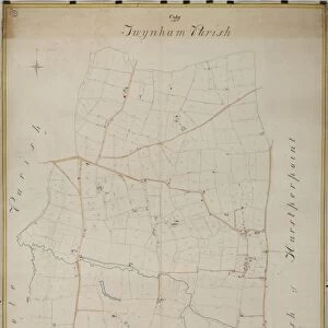
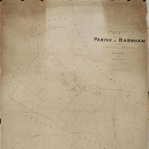
Canvas Print : Barnham Tithe Map, 1846


![]()
Canvas Prints from West Sussex County Council
Barnham Tithe Map, 1846
By Thomas Wisdom. 26.6 in. to 1 m. Original map size 65in. × 50in.
Tithe Award Map Collection
West Sussex Record Office Ref No: TD/W10
West Sussex County Council Record Office contains a fascinating history of the county of West Sussex, England
Media ID 7915652
© West Sussex County Council - All Rights Reserved
1840s Historical Mapping Parish
20"x16" (51x41cm) Canvas Print
"Discover the rich history of West Sussex with our stunning Canvas Print of the Barnham Tithe Map from 1846. This intricately detailed map, originally created by Thomas Wisdom, offers a fascinating glimpse into the past. Part of the West Sussex Record Office's Tithe Award Map Collection (TD/W10), this historic map is now available as a beautiful and unique home decor piece. Bring the history of Barnham directly to your walls with our high-quality Canvas Prints. Each print is expertly crafted using premium materials, ensuring vibrant colors and sharp details that bring the map to life. Order yours today and add a touch of history to your home or office."
Delivered stretched and ready to hang our premium quality canvas prints are made from a polyester/cotton blend canvas and stretched over a 1.25" (32mm) kiln dried knot free wood stretcher bar. Packaged in a plastic bag and secured to a cardboard insert for safe transit.
Canvas Prints add colour, depth and texture to any space. Professionally Stretched Canvas over a hidden Wooden Box Frame and Ready to Hang
Estimated Product Size is 40.6cm x 50.8cm (16" x 20")
These are individually made so all sizes are approximate
Artwork printed orientated as per the preview above, with portrait (vertical) orientation to match the source image.
FEATURES IN THESE COLLECTIONS
> Europe
> United Kingdom
> England
> Sussex
> Barnham
> Europe
> United Kingdom
> England
> Sussex
> Related Images
> Europe
> United Kingdom
> England
> West Sussex
> Related Images
> Maps and Charts
> Early Maps
> Maps and Charts
> Related Images
> West Sussex County Council
> West Sussex Record Office
> Tithe Award Maps, 1808-1859
EDITORS COMMENTS
This print showcases the Barnham Tithe Map, a remarkable piece of historical mapping created by Thomas Wisdom in 1846. Measuring an impressive 26.6 inches to 1 meter, the original map itself spans an astounding size of 65 inches by 50 inches. Preserved within the esteemed Tithe Award Map Collection at West Sussex Record Office, this artifact offers a fascinating glimpse into the past. The Barnham Tithe Map is a testament to meticulous craftsmanship and attention to detail. It meticulously depicts the parish during the 1840s, providing invaluable insights into land ownership and usage patterns of that era. Every intricate feature on this map tells a story - from sprawling fields and quaint cottages to winding roads and ancient landmarks. As part of West Sussex County Council's commitment to preserving our rich heritage, this print serves as both an educational resource and a visual delight for history enthusiasts. Its inclusion in their collection signifies its significance as a valuable historical document that sheds light on our ancestors' lives
MADE IN THE USA
Safe Shipping with 30 Day Money Back Guarantee
FREE PERSONALISATION*
We are proud to offer a range of customisation features including Personalised Captions, Color Filters and Picture Zoom Tools
SECURE PAYMENTS
We happily accept a wide range of payment options so you can pay for the things you need in the way that is most convenient for you
* Options may vary by product and licensing agreement. Zoomed Pictures can be adjusted in the Cart.