Home > Europe > United Kingdom > England > Kent > Great Chart
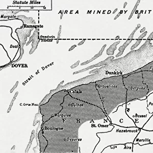
Map showing the area in the North Sea mined by the British during WWI, from The War Illustrated Album Deluxe, pub.1915

![]()
Wall Art and Photo Gifts from Fine Art Finder
Map showing the area in the North Sea mined by the British during WWI, from The War Illustrated Album Deluxe, pub.1915
3502686 Map showing the area in the North Sea mined by the British during WWI, from The War Illustrated Album Deluxe, pub.1915; (add.info.: Map showing the area in the North Sea mined by the British during WWI, from The War Illustrated Album Deluxe, pub.1915); Photo © Hilary Morgan
Media ID 38163104
© © Hilary Morgan / Bridgeman Images
Amred Forces Area Chart Coast Line Dover First War 1914 1918 Kent Mined North Strait Ww I Belgians Belgium Belgian Marines Maritime Force Naval Force Naval Infantry
FEATURES IN THESE COLLECTIONS
> Animals
> Birds
> Columbiformes
> Doves
> Related Images
> Europe
> Belgium
> Related Images
> Europe
> Republic of Ireland
> Maps
> Europe
> United Kingdom
> England
> Kent
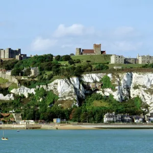
> Dover
> Europe
> United Kingdom
> England
> Kent
> Great Chart
> Europe
> United Kingdom
> England
> Kent
> Related Images
> Europe
> United Kingdom
> England
> Maps
> Europe
> United Kingdom
> Maps
> Fine Art Finder
> Artists
> Alexandre Marie Longuet
EDITORS COMMENTS
This historic print captures a detailed map showing the area in the North Sea mined by the British during World War I. Published in 1915 as part of The War Illustrated Album Deluxe, this image provides a glimpse into the strategic military operations of the time.
The map highlights key locations such as Dover and Kent along the coastline, where naval forces were stationed to defend against enemy attacks. It also showcases the extensive maritime activities undertaken by the British navy during this tumultuous period in history.
As Europe was engulfed in conflict, with Belgium at its epicenter, Britain played a crucial role in supporting its allies and safeguarding its own shores. The intricate details on this map serve as a testament to the meticulous planning and execution required for wartime operations.
From naval infantry to armed forces, every branch of service is represented on this map, symbolizing unity and strength in the face of adversity. The Great War may have been a dark chapter in human history, but it also brought out acts of bravery and heroism that are immortalized through images like these.
This print is not just a historical artifact; it is a reminder of sacrifices made and victories achieved during one of the most challenging periods our world has ever faced.
MADE IN THE USA
Safe Shipping with 30 Day Money Back Guarantee
FREE PERSONALISATION*
We are proud to offer a range of customisation features including Personalised Captions, Color Filters and Picture Zoom Tools
SECURE PAYMENTS
We happily accept a wide range of payment options so you can pay for the things you need in the way that is most convenient for you
* Options may vary by product and licensing agreement. Zoomed Pictures can be adjusted in the Cart.