Home > Arts > Watercolor paintings
The City of New York, as laid out by the Commissioners with the Surrounding COuntry

![]()
Wall Art and Photo Gifts from Fine Art Finder
The City of New York, as laid out by the Commissioners with the Surrounding COuntry
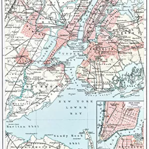
1079213 The City of New York, as laid out by the Commissioners with the Surrounding COuntry, by their Secretary and Surveyor John Randel, Jr. 1814, 1814 (Pen-and-ink, watercolour on paper.) by Randel, John Jr. (fl.c.1807-14); 81x52 cm; Collection of the New-York Historical Society, USA; (add.info.: The City of New York, as laid out by the Commissioners with the Surrounding Country, by their Secretary and Surveyor John Randel, Jr. 1814); eNew York Historical Society; American, out of copyright
Media ID 22493254
© New York Historical Society / Bridgeman Images
Borough Boroughs Brooklyn Land Manhattan New Jersey Queens Survey Surveys
FEATURES IN THESE COLLECTIONS
> Europe
> France
> Canton
> Landes
> Fine Art Finder
> Artists
> American School
> Fine Art Finder
> Artists
> John Jr. Randel
> Maps and Charts
> Early Maps
> Maps and Charts
> Related Images
> North America
> United States of America
> Maps
> North America
> United States of America
> New Jersey
> Jersey City
> North America
> United States of America
> New Jersey
> Related Images
> North America
> United States of America
> New York
> New York
> Bronx
> Related Images
> North America
> United States of America
> New York
> New York
> Brooklyn
> Related Images
EDITORS COMMENTS
This print showcases "The City of New York, as laid out by the Commissioners with the Surrounding Country" in 1814. Created by John Randel Jr. , the Secretary and Surveyor for the Commissioners, this pen-and-ink watercolor on paper provides a fascinating glimpse into the history and development of one of America's most iconic cities. Measuring 81x52 cm, this meticulously detailed map offers an intricate representation of New York City during its early years. With its boroughs, including Manhattan, Queens, Brooklyn, The Bronx, and even parts of New Jersey depicted within its borders, it serves as a valuable historical document that captures the city's growth and expansion. As we explore this image further, we are transported back in time to witness how urban planning played a crucial role in shaping New York City. The precision with which Randel Jr. executed his survey is evident through every street grid and landmark illustrated on this map. Preserved within the collection of the New-York Historical Society in the USA, this artwork not only celebrates American history but also highlights Randel Jr. 's significant contribution to urban development. It stands as a testament to his expertise as he meticulously documented each detail for future generations to appreciate. Through this print from Fine Art Finder by Bridgeman Images, viewers can immerse themselves in both nostalgia and admiration for a city that has continuously evolved while retaining elements of its past glory.
MADE IN THE USA
Safe Shipping with 30 Day Money Back Guarantee
FREE PERSONALISATION*
We are proud to offer a range of customisation features including Personalised Captions, Color Filters and Picture Zoom Tools
SECURE PAYMENTS
We happily accept a wide range of payment options so you can pay for the things you need in the way that is most convenient for you
* Options may vary by product and licensing agreement. Zoomed Pictures can be adjusted in the Cart.