Home > North America > United States of America > New York > New York > Maps
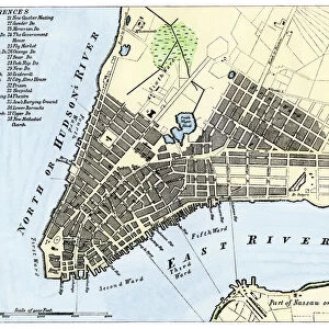
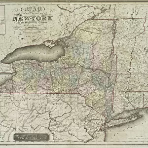
Map of the City of New-York [in Manhattan, as far north as 36th Street]
![Map of the City of New-York [in Manhattan, as far north as 36th Street]](/p/690/map-city-new-york-in-manhattan-22633140.jpg.webp "Map of the City of New-York [in Manhattan, as far north as 36th Street]")
![]()
Wall Art and Photo Gifts from Fine Art Finder
Map of the City of New-York [in Manhattan, as far north as 36th Street]
1079268 Map of the City of New-York [in Manhattan, as far north as 36th Street], 1846 (black ink on paper) by American School, (19th century); 33x27 cm; Collection of the New-York Historical Society, USA; (add.info.: " for New York as it is in 1846"
David H. Burr); eNew York Historical Society; American, out of copyright
Media ID 22633140
© New York Historical Society / Bridgeman Images
Brooklyn Downtown East River Lower Manhattan Manhattan Pier Piers Survey Surveys
FEATURES IN THESE COLLECTIONS
> Arts
> Artists
> B
> David Burr
> Arts
> Landscape paintings
> Waterfall and river artworks
> River artworks
> Arts
> Portraits
> Pop art gallery
> Street art portraits
> Fine Art Finder
> Artists
> American School
> Maps and Charts
> Early Maps
> Maps and Charts
> Related Images
> North America
> United States of America
> Maps
> North America
> United States of America
> New York
> New York
> Brooklyn
> Related Images
> North America
> United States of America
> New York
> New York
> Manhattan
> Related Images
> North America
> United States of America
> New York
> New York
> Maps
EDITORS COMMENTS
This black ink print from 1846 showcases a detailed "Map of the City of New-York [in Manhattan, as far north as 36th Street]". Created by the American School in the 19th century, this historical artifact measures 33x27 cm and is currently held in the esteemed collection of the New-York Historical Society in the USA. The map was originally designed by David H. Burr and offers a fascinating glimpse into what New York looked like during that era. The intricate details on this map provide an invaluable resource for understanding how Lower Manhattan was structured at that time. From its bustling streets to its prominent piers along the East River, every aspect has been meticulously captured. This piece not only serves as a visual representation but also acts as a survey document showcasing various landmarks and important locations throughout downtown. As one explores this remarkable artwork, it becomes evident that it goes beyond just being a mere map; it encapsulates America's rich history and highlights how Manhattan played a pivotal role in shaping our nation's identity. With Brooklyn visible across the river, this print reminds us of New York City's interconnectedness even back then. Preserved with utmost care by Bridgeman Images' Fine Art Finder, this extraordinary piece invites viewers to immerse themselves in an era long gone while appreciating the artistry involved in creating such an accurate depiction of early Manhattan life.
MADE IN THE USA
Safe Shipping with 30 Day Money Back Guarantee
FREE PERSONALISATION*
We are proud to offer a range of customisation features including Personalised Captions, Color Filters and Picture Zoom Tools
SECURE PAYMENTS
We happily accept a wide range of payment options so you can pay for the things you need in the way that is most convenient for you
* Options may vary by product and licensing agreement. Zoomed Pictures can be adjusted in the Cart.