Home > Animals > Mammals > Cats (Domestic) > Russian White
Map showing the partitions of Poland, 18th century. (print)
")
![]()
Wall Art and Photo Gifts from Fine Art Finder
Map showing the partitions of Poland, 18th century. (print)
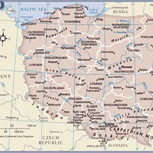
7420057 Map showing the partitions of Poland, 18th century. (print); (add.info.: Map showing the partitions of Poland, from top left, Poland before 1772, after 1772, after 1793 and after 1795. They were three partitions of the Polish-Lithuanian Commonwealth that ended the existence of the state, resulting in the elimination of sovereign Poland and Lithuania for 123 years and were conducted by the Habsburg monarchy, the Kingdom of Prussia, and the Russian Empire. From the book Outline of History by H.G. Wells, published 1920.); Photo © Ken Welsh. All rights reserved 2024
Media ID 38510236
© © Ken Welsh. All rights reserved 2024 / Bridgeman Images
Ageing Chart Diagram Governement Graph Habsburg House Habsburg Monarchy Hapsburg Poland Poland Polish Pole Polish Run Down State State Government 18th Centuries Geographer
FEATURES IN THESE COLLECTIONS
> Animals
> Mammals
> Cats (Domestic)
> Russian White
> Europe
> Lithuania
> Posters
> Europe
> Lithuania
> Related Images
> Europe
> Poland
> Related Images
> Fine Art Finder
> Artists
> Arnold Colom
> Maps and Charts
> Early Maps
EDITORS COMMENTS
This print showcases a map illustrating the partitions of Poland in the 18th century, a pivotal moment in European history. Divided into four sections - before 1772, after 1772, after 1793, and after 1795 - this map highlights the three partitions of the Polish-Lithuanian Commonwealth that ultimately led to the disappearance of sovereign Poland and Lithuania for over a century.
Executed with intricate detail and precision, this engraving from H.G. Wells' "Outline of History" offers a glimpse into the geopolitical turmoil that reshaped Eastern Europe during this tumultuous period. The partitions were orchestrated by powerful entities such as the Habsburg monarchy, Kingdom of Prussia, and Russian Empire, each vying for control over Polish territories.
As you study this historical artifact, you can't help but feel a sense of melancholy at witnessing the demise of an ancient state that once wielded significant influence across the continent. The black-and-white aesthetic adds to its somber tone, emphasizing the gravity of these events that forever altered the course of Polish history.
This print serves as a poignant reminder of how political machinations can have far-reaching consequences on nations and their people. It stands as a testament to resilience and perseverance in the face of adversity—a story waiting to be discovered within its faded lines and borders.
MADE IN THE USA
Safe Shipping with 30 Day Money Back Guarantee
FREE PERSONALISATION*
We are proud to offer a range of customisation features including Personalised Captions, Color Filters and Picture Zoom Tools
SECURE PAYMENTS
We happily accept a wide range of payment options so you can pay for the things you need in the way that is most convenient for you
* Options may vary by product and licensing agreement. Zoomed Pictures can be adjusted in the Cart.