Home > Europe > United Kingdom > England > London > Sport > Sailing
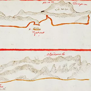
Cabo San Lorenzo and Manta, 1682 (coloured manuscript)
")
![]()
Wall Art and Photo Gifts from Fine Art Finder
Cabo San Lorenzo and Manta, 1682 (coloured manuscript)
7339603 Cabo San Lorenzo and Manta, 1682 (coloured manuscript) by Ringrose, Basil (c.1653-83); 16x20 cm; National Maritime Museum, London, UK; (add.info.: Creator: Basil Ringrose
Bound sheet. Col. ms. Additional Places: Ecuador.
From a book of sailing directions of 110ff: The South Sea Waggoner shewing the making & bearing of all the coasts from California to the Streights of Le Maire done from the Spanish originall by Basil Ringrose'.
The charts all have a square pencil grid for making copies.); © National Maritime Museum, Greenwich, London
Media ID 38410058
© © National Maritime Museum, Greenwich, London / Bridgeman Images
Boat Dock Coast Line Colony Ecuador Equatorian Equatorians Harbor Area Harbour Area Harbours Latin America Port Area Seawater Geographer Latine America
FEATURES IN THESE COLLECTIONS
> Animals
> Mammals
> Cricetidae
> California Mouse
> Arts
> Realistic drawings
> Pencil drawings
> Fine art
> Europe
> United Kingdom
> England
> London
> Boroughs
> Greenwich
> Europe
> United Kingdom
> England
> London
> Museums
> Greenwich Heritage Centre
> Europe
> United Kingdom
> England
> London
> Museums
> National Maritime Museum
> Europe
> United Kingdom
> England
> London
> Sport
> Sailing
> Europe
> United Kingdom
> England
> London
> Towns
> Greenwich
> Europe
> United Kingdom
> Heritage Sites
> Maritime Greenwich
> Europe
> United Kingdom
> Maps
> Fine Art Finder
> Artists
> Basil Ringrose
EDITORS COMMENTS
This stunning coloured manuscript print from 1682 showcases the beautiful coastlines of Cabo San Lorenzo and Manta, captured by Basil Ringrose. The intricate details and vibrant colors bring to life the South American landscapes as seen through the eyes of a skilled cartographer in the 17th century.
The manuscript is part of a book of sailing directions, providing valuable information for sailors navigating the waters from California to the Straits of Le Maire. Each chart includes a square pencil grid for making copies, highlighting the practicality and precision required for seafaring journeys during this era.
As you gaze upon this historical artwork, you can almost feel the sense of adventure and exploration that must have accompanied those who relied on such maps for their travels. The combination of artistry and functionality in these drawings serves as a reminder of both the beauty and utility found in early maritime cartography.
Transport yourself back in time to an age when discovery was at its peak with this image capturing a moment in history along the coasts of Ecuador. Let your imagination set sail as you explore this fascinating piece from National Maritime Museum's collection.
MADE IN THE USA
Safe Shipping with 30 Day Money Back Guarantee
FREE PERSONALISATION*
We are proud to offer a range of customisation features including Personalised Captions, Color Filters and Picture Zoom Tools
SECURE PAYMENTS
We happily accept a wide range of payment options so you can pay for the things you need in the way that is most convenient for you
* Options may vary by product and licensing agreement. Zoomed Pictures can be adjusted in the Cart.