Home > Animals > Mammals > Cricetidae > California Mouse
Map of El Viejo, 1682 (paper)
")
![]()
Wall Art and Photo Gifts from Fine Art Finder
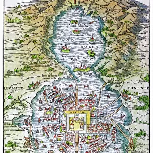
Map of El Viejo, 1682 (paper)
7339597 Map of El Viejo, 1682 (paper) by Ringrose, Basil (c.1653-83); 16x20 cm; National Maritime Museum, London, UK; (add.info.: Creator: Basil Ringrose
The map also shows Nicaragua, Latitude is noted, shallows and anchorage are marked and a ship is shown coming by river from Fonseca.It's from a book of sailing directions of 110ff: The South Sea Waggoner shewing the making & bearing of all the coasts from California to the Streights of Le Maire done from the Spanish originall by Basil Ringrose'. The charts all have a square pencil grid for making copies. The source was a Spanish derrotero captured by Captain Sharpe in the Trinity, with Ringrose on board, from the Spanish ship Rosario off modern Ecuador on 29 July 1681.); © National Maritime Museum, Greenwich, London
Media ID 38410056
© © National Maritime Museum, Greenwich, London / Bridgeman Images
FEATURES IN THESE COLLECTIONS
> Animals
> Mammals
> Cricetidae
> California Mouse
> Arts
> Landscape paintings
> Waterfall and river artworks
> River artworks
> Arts
> Realistic drawings
> Pencil drawings
> Fine art
> Europe
> Spain
> Related Images
> Europe
> United Kingdom
> England
> London
> Boroughs
> Greenwich
> Europe
> United Kingdom
> England
> London
> Museums
> Greenwich Heritage Centre
> Fine Art Finder
> Artists
> Basil Ringrose
EDITORS COMMENTS
This stunning print of the Map of El Viejo, dating back to 1682, offers a fascinating glimpse into the cartography of the 17th century. Created by Basil Ringrose, this intricate map not only showcases El Viejo in Nicaragua but also includes detailed notes on latitude, shallows, and anchorage points. The presence of a ship coming upriver from Fonseca adds a sense of movement and exploration to the scene.
Part of a larger book of sailing directions known as 'The South Sea Waggoner,' this map was meticulously drawn with a square pencil grid for easy replication. Its origin can be traced back to a Spanish derrotero captured by Captain Sharpe in 1681, highlighting the interconnectedness and exchange between different seafaring nations during that time.
The vibrant colors used in this artwork bring life to the historical details depicted on paper. From the coastlines to inland territories, every element is carefully illustrated with precision and care. This piece serves as both an informative tool for navigation and a work of art that captures the spirit of exploration in the early modern era.
Displayed at the National Maritime Museum in London, this Map of El Viejo is not just a geographical representation but also a testament to human curiosity and ingenuity in mapping out unknown lands centuries ago.
MADE IN THE USA
Safe Shipping with 30 Day Money Back Guarantee
FREE PERSONALISATION*
We are proud to offer a range of customisation features including Personalised Captions, Color Filters and Picture Zoom Tools
SECURE PAYMENTS
We happily accept a wide range of payment options so you can pay for the things you need in the way that is most convenient for you
* Options may vary by product and licensing agreement. Zoomed Pictures can be adjusted in the Cart.